Private Silver Circle Day Tour with Hvammsvik Baths
199.900 ISK
8 ore

Facile
250.000 ISK
Nota bene:
Il tempo può essere imprevedibile in Islanda quindi durante l'inverno ci si può aspettare che occasionalmente dobbiamo alterare l'itinerario del tour se le condizioni meteo/stradali sono sfavorevoli.
Disponibile: Tutto l'anno
Durata: Circa 12 ore, a seconda del tempo trascorso ad ogni fermata e della durata di qualsiasi attività aggiunta.
Ritiro: Dal tuo hotel/alloggio all'interno della Reykjavik Capital Area.
In evidenza
Descrizione
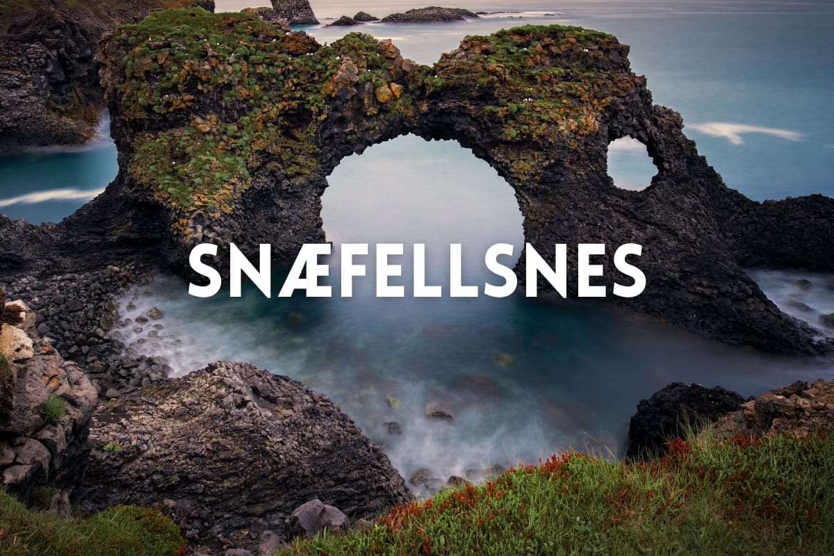
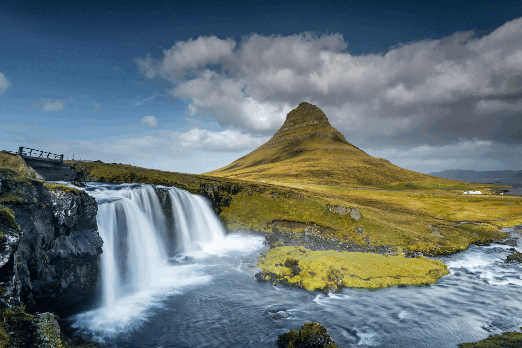
Snæfellsnes è una penisola che possiede una grande diversità di ciò che l'Islanda ha da offrire I suoi paesaggi unici di aspri campi di lava coltivati a muschio, affascinanti piccoli villaggi di pescatori lungo la costa e la ricchezza di resti e storia risalenti al periodo di insediamento e la formazione dell'Islanda, rende per un'intera giornata di "Islanda in miniatura" Il Parco nazionale di Snæfellsnes è il primo parco nazionale in Islanda ad estendersi dalla cima di una montagna con i suoi confini che si estendono nell'oceano All'estremità del Parco Nazionale di Snæfellsnes si erge il rinomato ghiacciaio Snæfellsjökull, ritenuto uno dei sette centri energetici o chakra del mondo per via dei grandi poteri e dell'energia che molte persone percepiscono quando sono in sua presenza, svolge un ruolo importante in Jules Verne' fantascienza Viaggio al Centro della Terra pubblicato nel 1864 e un film con lo stesso nome nel 2008 con protagonista Brendan Fraser e l'attrice islandese Anita Briem.
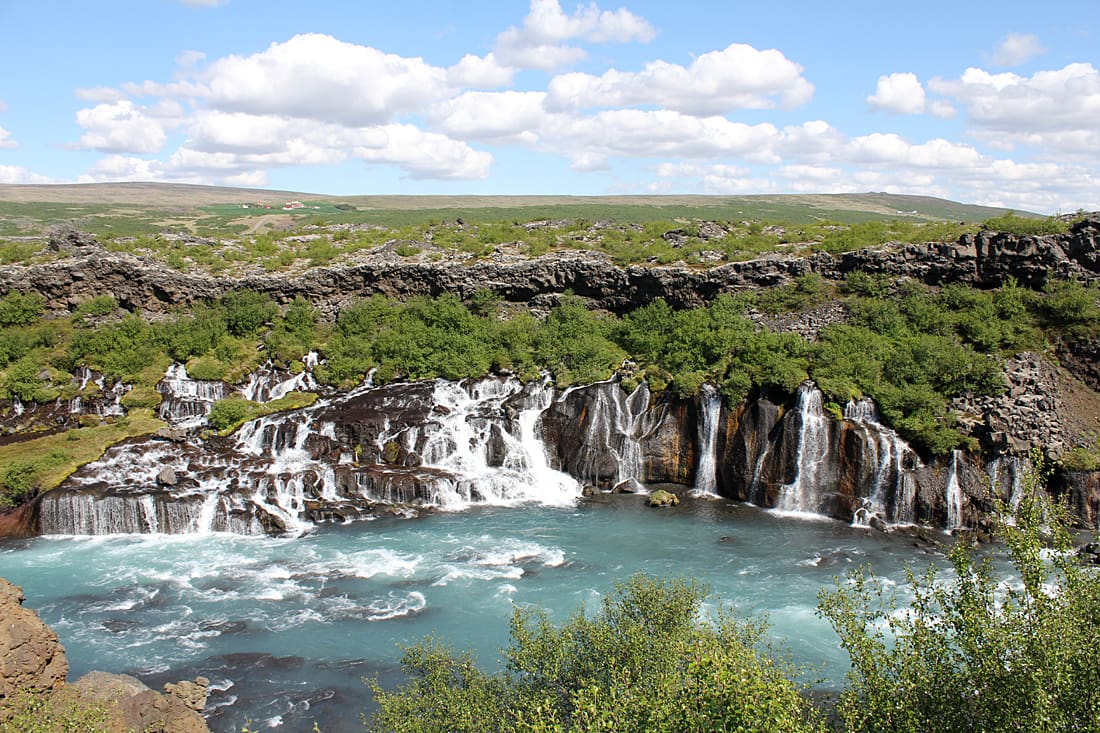
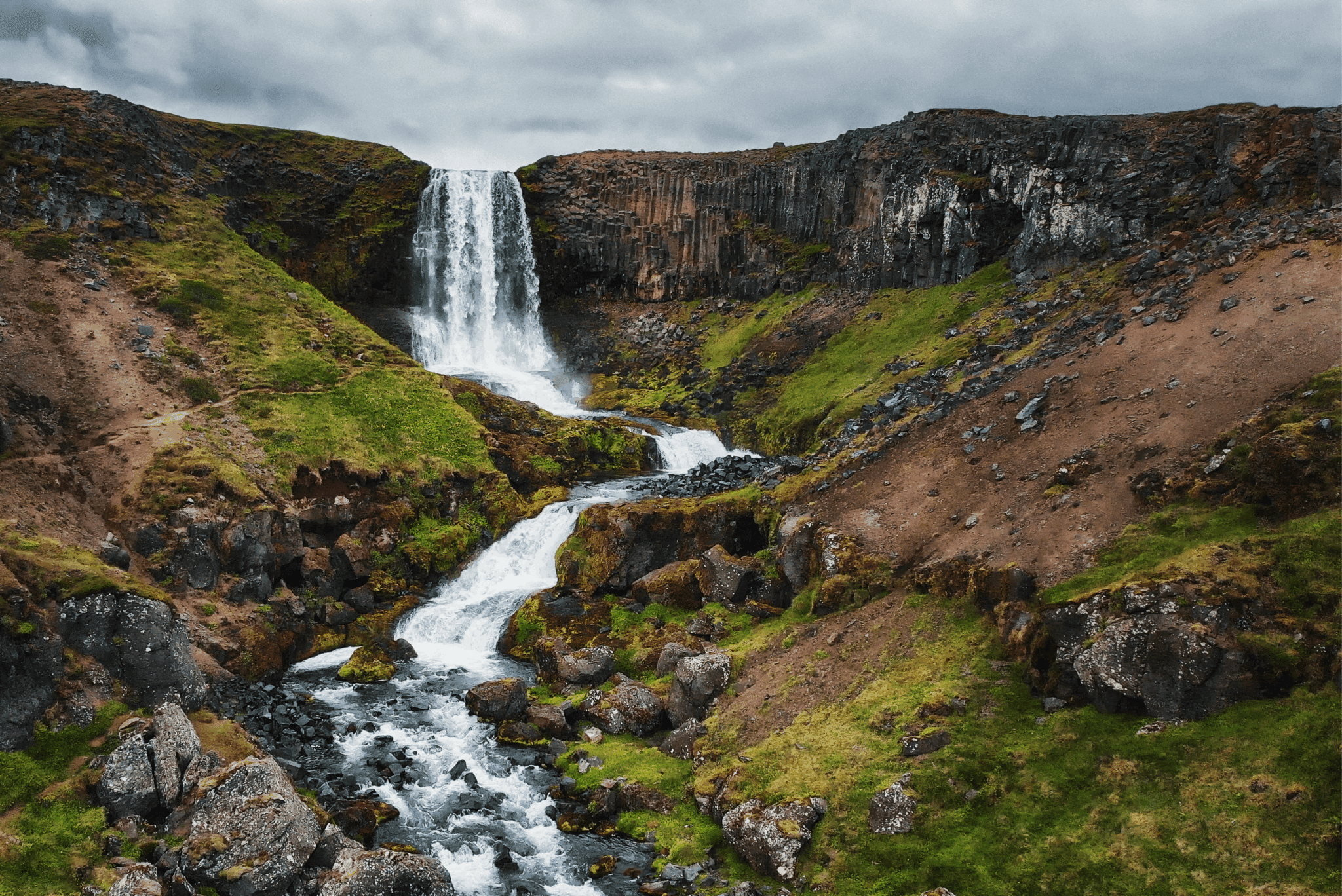
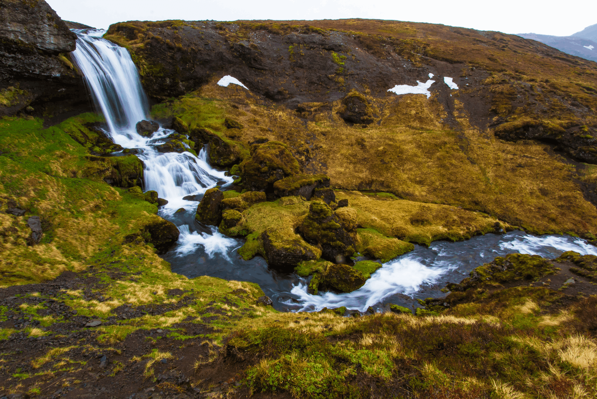
Arrivando alla penisola di Snæfellsnes, ci dirigeremo dall'area della capitale Reykjavik alla Hvalfjörður fiordo e guidare attraverso il Hvalfjarðargöng tunnel stradale sotterraneo, il primo tunnel sottomarino ad essere costruito in Islanda e tra i tunnel stradali sottomarini più lunghi del mondo Prima di arrivare a Snæfellsnes passeremo in auto Borgarfjarðarbrú bridge, il secondo ponte più lungo d'Islanda, e fai una sosta nella città di Borgarnes per rinfreschi e servizi igienici, e per sgranchirci le gambe Dopo aver guidato oltre un sacco di belle fattorie ci accendiamo a Vatnaleið, un passo di montagna tra le coste nord e sud della penisola di Snæfellsnes, e fermarsi in una sosta presso il Fossá fiume Da lì avrete una vasta vista sul Selvallavatn lago circondato dall'aspro di 4.000 anni Berserkjahraun campo di lava che è stato creato in un'eruzione di una fila di quattro crateri scoria A pochi passi dal punto di sosta si porta al a due ledged Selvallafoss cascata che è anche conosciuta come Cascata delle pecore a causa delle pecore che a volte poggiano su una sporgenza dietro di essa. Guidiamo un po' più lontano e ci fermiamo vicino a uno dei crateri scoria che hanno creato Berserkjahraun, l'alto e il largo Grákúla. Deriva il suo nome dal muschio grigio che ricopre questo cratere altrimenti splendidamente di colore rosso. Ora facciamo un'altra svolta e guidiamo attraverso i campi di lava di Berserkjahraun per raggiungere Grundarfjörður, la città di pescatori attenta all'ambiente che si trova alle radici del pittoresco Kirkjufell montagna. Se sei un Il Trono di Spade fan, riconoscerete subito questa montagna come Montagna della punta della freccia nelle stagioni 6 e 7. insieme alla piccola cascata Kirkjufellsfoss, questa coppia costituisce l'attrazione principale e il punto di riferimento di Grundarfjörður e uno dei luoghi più fotografati in Islanda. Successivamente, guidiamo lungo la riva fino alla vecchia città mercato Ólafsvík che era una delle più grandi stazioni commerciali in Islanda Consigliamo vivamente di pranzare nel nostro ristorante preferito qui che offre una gamma di deliziosi corsi con pesce appena pescato dal porto (e per coloro che sono vegani, hanno anche una varietà di ottimi piatti vegani sul loro menu) Dopo un breve tragitto in auto da Ólafsvík, ci fermiamo in un parcheggio per un breve tratto a piedi fino a una piattaforma panoramica per ammirare la bellissima cascata Svöðufoss, cadendo con grazia da una scogliera color basalto.
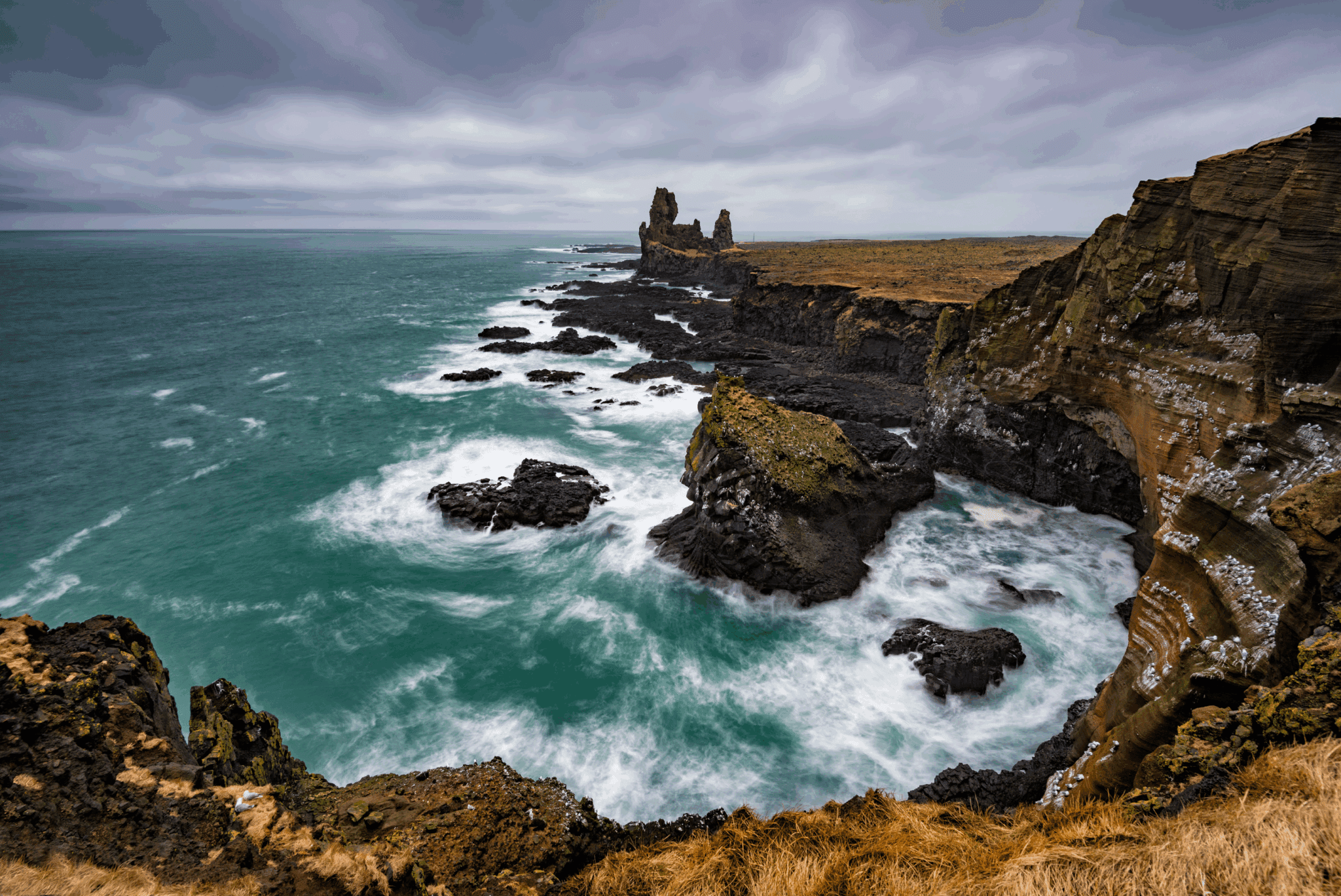
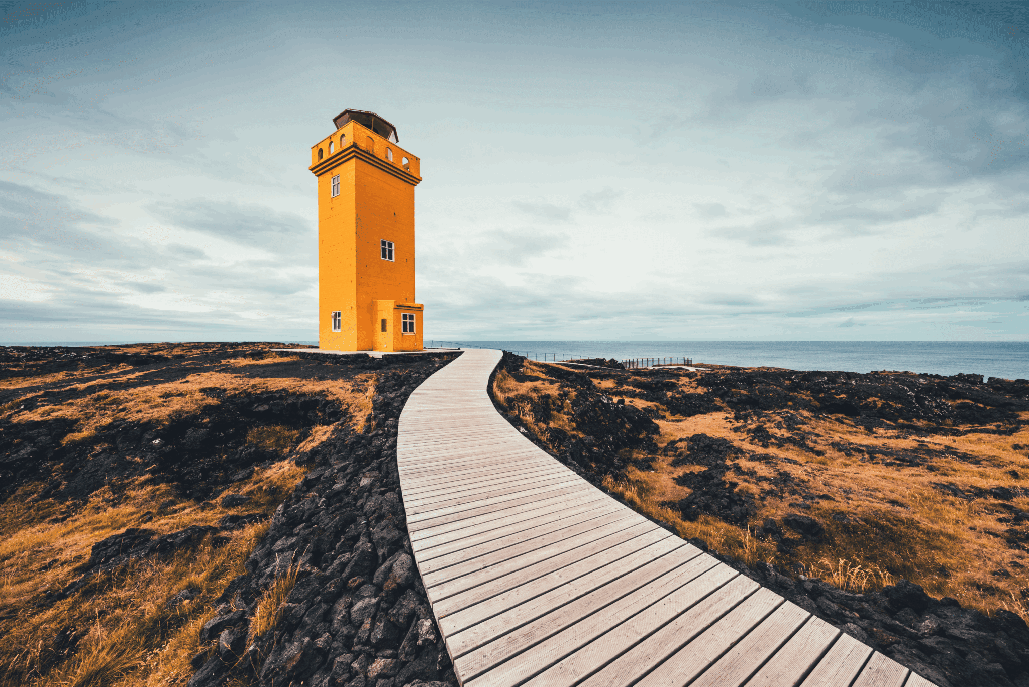
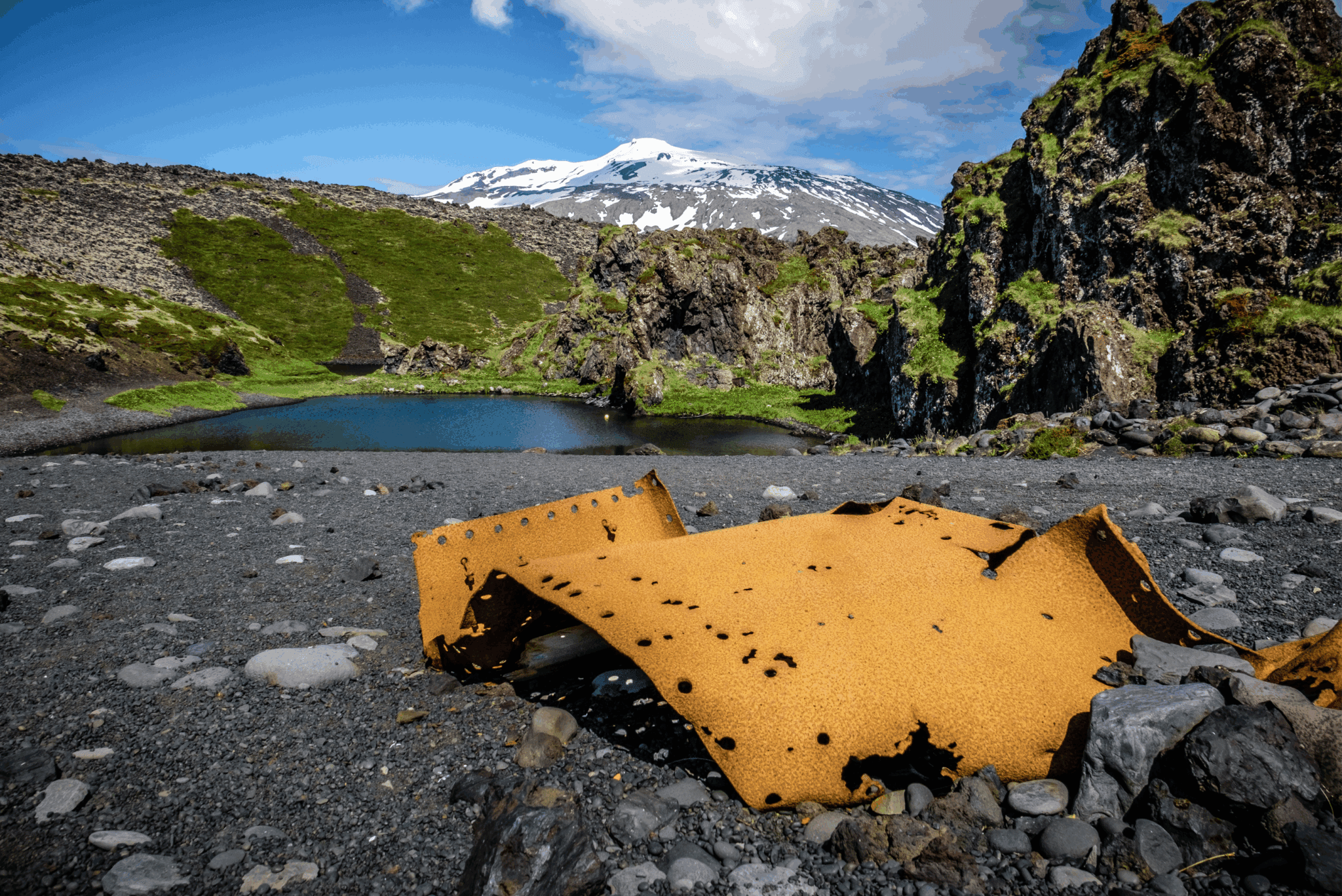
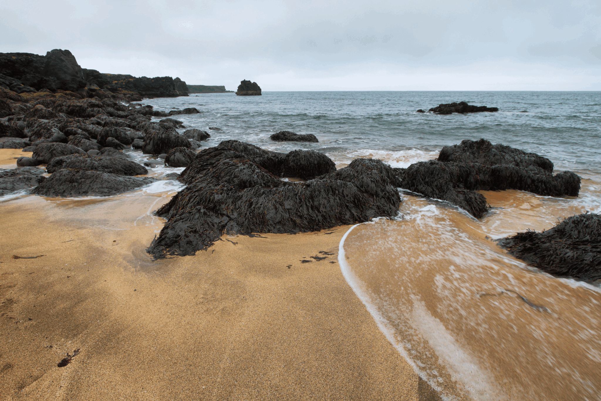
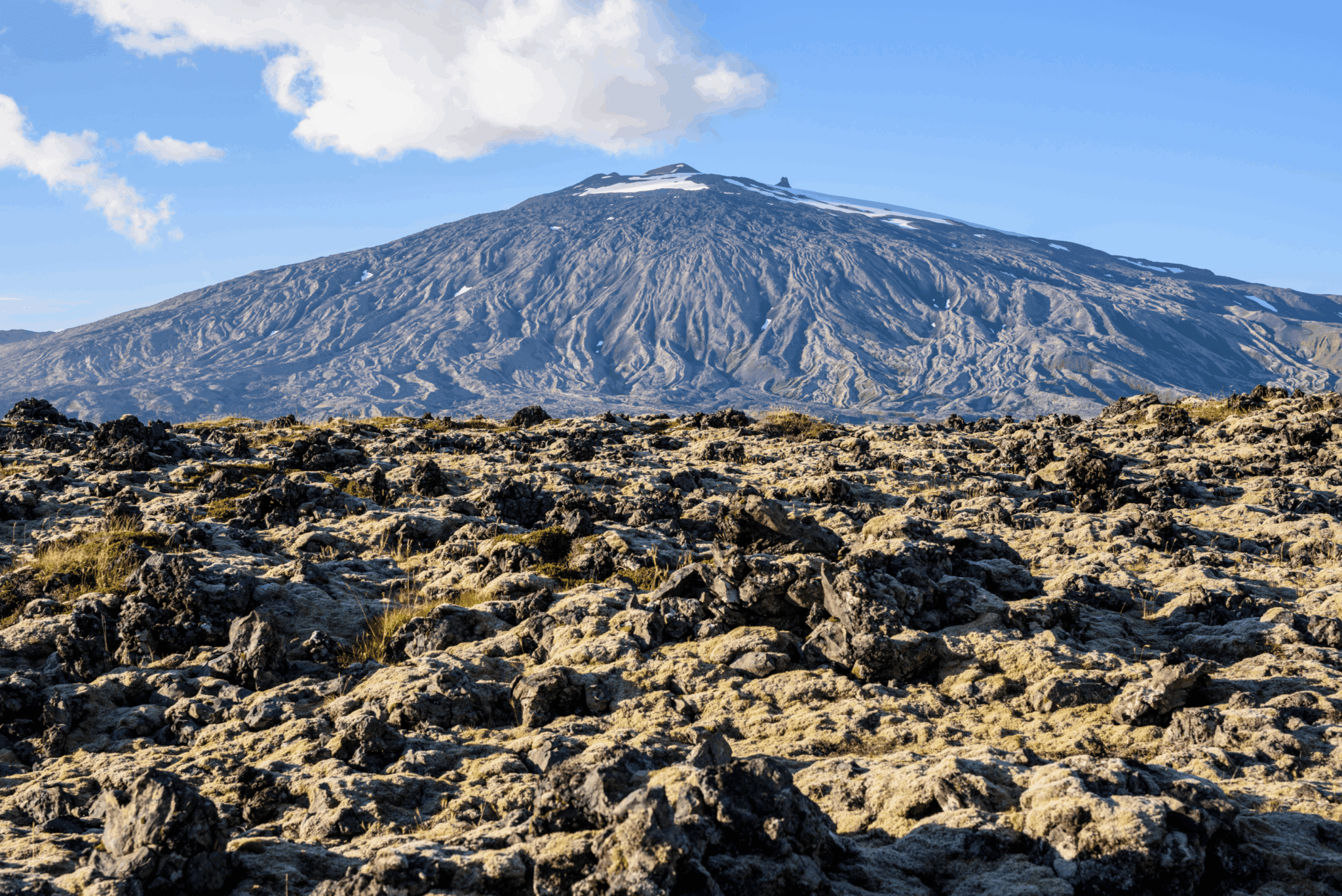
Ora raggiungiamo l'estremità di Snæfellsnes e ci fermiamo dalla bellissima spiaggia Skarðsvík che è diverso dalle spiagge nere dell'Islanda Questa spiaggia appartata ha sabbia dorata circondata da colonne di basalto fratturate di colore nero profondo e un oceano luminoso color acquamarina Più a ovest ci fermiamo al primo faro della giornata sul capo Öndverðarnes. Per oltre 700 anni dal XIII secolo, questa era una vecchia stazione di pesca con un sacco di capanne di pescatori e una cappella in loco Vecchie reliquie e rovine di quel tempo si possono trovare nella zona, ma ora il piccolo faro di colore arancione Öndverðarnesviti sorge sul suo punto più occidentale A sud di esso sorge un altro faro arancione con due nomi; Svörtuloftaviti quando visto dal mare e Skálasnagaviti sulla terraferma La linea costiera tra questi fari è chiamata Svörtuloft o Soffitti Neri, derivando le ripide scogliere di lava nera come la pece su cui molte navi si sono schiantate e frantumate in condizioni meteorologiche estreme. Ora affianchiamo il punto di riferimento principale della penisola di Snæfellsnes e guidiamo la calotta del ghiacciaio Snæfellsjökull. Dominando la zona, si dice che questo misterioso ghiacciaio mantenga grandi segreti Si ritiene che il mezzo uomo mezzo troll e protettore di Snæfellsnes Bárður Snæfellsás vive in esso, scomparso dopo un incidente familiare tragico Snæfellsjökull è un vulcano attivo che ha eruttato l'ultima volta 1.8000 anni fa, quindi in cima a questo ghiacciaio alto 1.446 m si trova una ciotola di cratere profonda 200 m Continuiamo la nostra strada verso la spiaggia di ciottoli neri di Djúpalónssandur. Un sentiero pedonale attraverso un campo di lava ti porta a questa magnifica spiaggia con i resti del naufragio del peschereccio britannico del 1948 Epino GY7 sparsi intorno Sia i ciottoli di questa spiaggia che il naufragio sono protetti, quindi devono essere tenuti lì e non rimossi Si prega di ammirare attentamente questa zona panoramica e di badare alle forti onde che arrivano a terra Un'altra riva nelle vicinanze ti offre una vista sorprendente di varie formazioni rocciose da un ponte di osservazione, tutto fino alla zona agricola abbandonata Malarrif dove il faro alto 24 m Malarrifsviti stand. Presso il ponte di osservazione si trova il promontorio di palagonite Svalþúfa con una scogliera chiamata ←úfubjarg sotto il quale si trovano vari uccelli marini nidificanti, appena fuori dalla riva si trovano i due pinnacoli rocciosi Lóndrangar, ritenuta la chiesa degli elfi e la loro biblioteca.
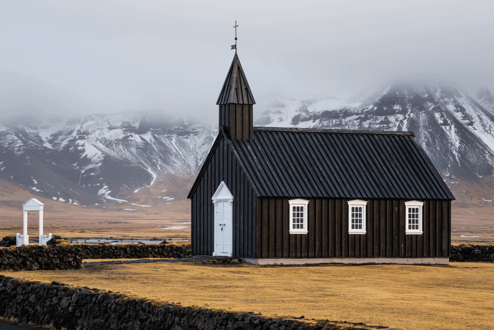
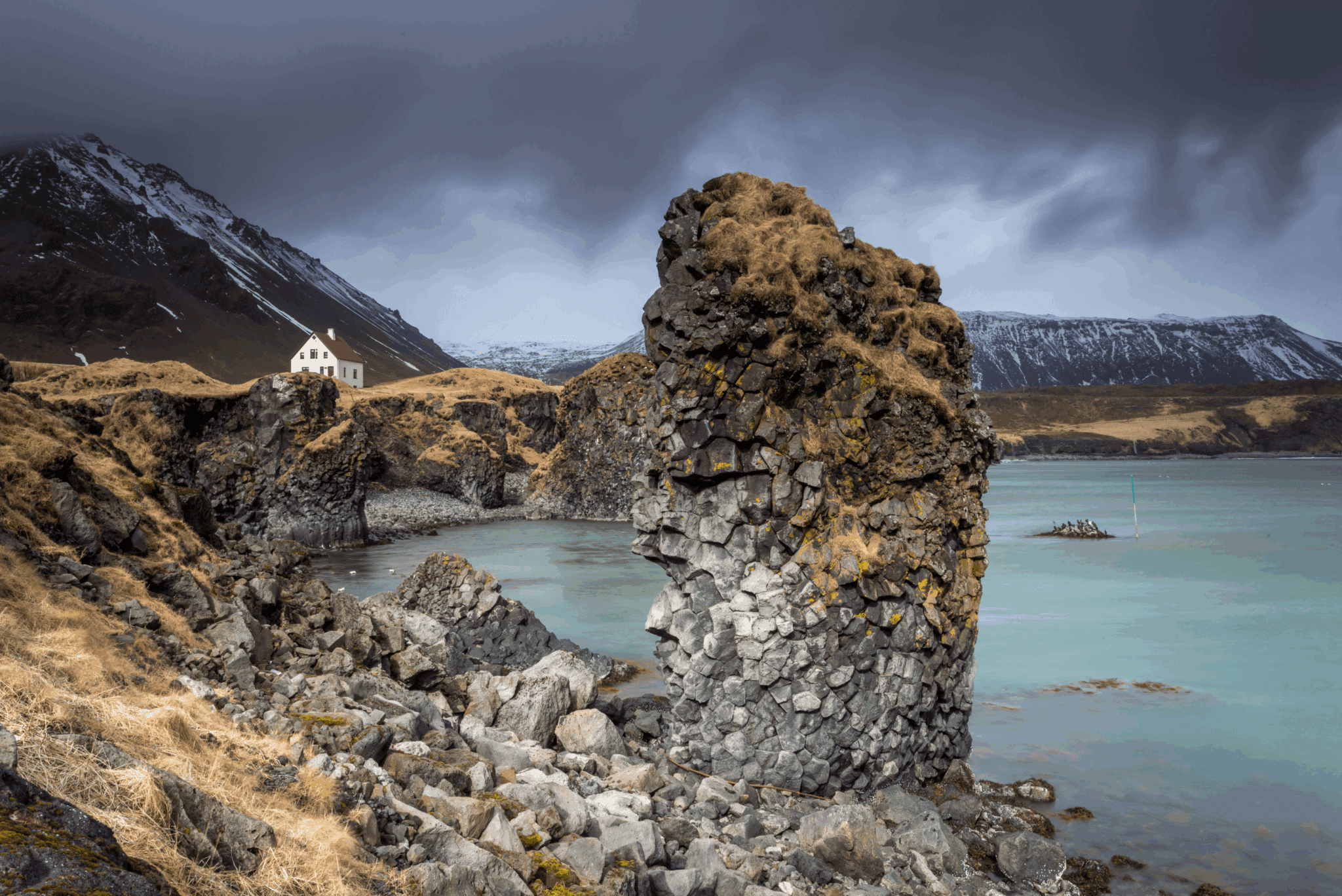
Seguono i villaggi gemelli di Hellnar e Arnarstapi. Hellnar era una grande vecchia stazione di pesca risalente al 1560 ma ora ci vivono solo poche persone Un accogliente piccolo caffè in riva alla spiaggia Hellnafjara è popolare per le splendide viste che offre dal suo patio e giù dalla spiaggia si trova la notevole grotta Baðstofa all'interno del masso sporgente Valasnoti. La sua magica unicità risiede nella colorazione all'interno formata dalle maree e da diversi fulmini che colpiscono le scaglie delle rocce all'interno Arnarstapi è un piccolo villaggio di pescatori con strane formazioni rocciose lungo la sua costa e scogliere piene di uccelli marini nidificanti Primo, sei accolto dall'enorme statua di Bárður Snæfellsás, il già citato protettore di Snæfellsnes Poi un sentiero a piedi vi porta lungo la costa per ammirare varie formazioni di lava e basalto L'arco di roccia Gatklettur si estende dalle scogliere con un grande buco attraverso, e più avanti, ci sono tre buchi nel terreno con l'oceano che entra e pareti scogliere di basalto con uccelli marini che nidificano in alcuni giorni le forti onde dell'oceano schizzano in aria da questi burroni Verso la fine di questo tour, guidiamo attraverso terreni agricoli vicino a campi di lava, e una di queste fattorie era la casa di un famigerato assassino. Axlar-Björn è stato il primo serial killer in Islanda ED è ancora l'unico Viveva nella fattoria Öxl in the 16th century, where he would kill travelers passing by with an axe. Hiding their bodies in the cowshed, killed 9 people and kept their belongings until one traveler managed to escape. That led to the arrest of Björn who was sentenced to death. Before he was beheaded, his limbs were crushed with a sledgehammer and his body was cut down and put up on poles, and then his body parts were dug in three graves, to prevent him from returning to haunt the living, with cairns on top. One of these cairns still stands in a lava field by Hellnar and is declared protected. After we've passed Öxl we turn to the very small village of Búðir by the edge of the pitch-black Búðahraun lava field. One of the most photographed churches in Iceland is the black wooden Búðakirkja church with its white window and door frames and a stonewall around its graveyard. It's a replica of the former church and the only reminder left of this former vibrant fishing village. Further down is a green-yellowish beach of olivine sand, which is very rare in the world. We make our way to our last stop which is the golden sand beach Ytri-Tunga. It has a large seal colony and is very popular for seal watching, especially over summer. Two seal species, the harbor seal and the grey seal reside here peacefully in harmony. Seals used to be vital for the survival of Icelanders, but now it is prohibited to hunt these beautiful creatures in Icelandic territory.
Vatnaleið is a mountain pass between the north and south coasts of the Snæfellsnes peninsula. It first opened in 2001, superseding the gravel road over the Kerlingaskarð pass. A rest stop by the river Fossá on this route has tables and chairs made from basalt rocks which were found during the construction of Vatnaleið. From there you have a vast view over the lake Selvallavatn and the surrounding lava field and mountain rows. A short walk up the Fossá river takes you to a two-ledged waterfall called Selvallafoss – also known as Sheep’s Waterfall due to sheep sometimes resting on a ledge behind it. Further down this route is the 80 m (262 ft) high and 211 m (629 ft) wide scoria crater Gráakúla (mistakenly called Grákúla by some) which formed over 4,000 years ago. Being red, it is also covered with grey moss which gives its name (Grákúla = e. Grey Bump). It is the second-largest crater in a row of four scoria craters that erupted over 4,000 years ago, with lava flowing in the NW direction creating the rugged Berkserkjahraun Aa lava field. The eruption of Grákúla created the Selvallavatn lake situated just south of the crater.
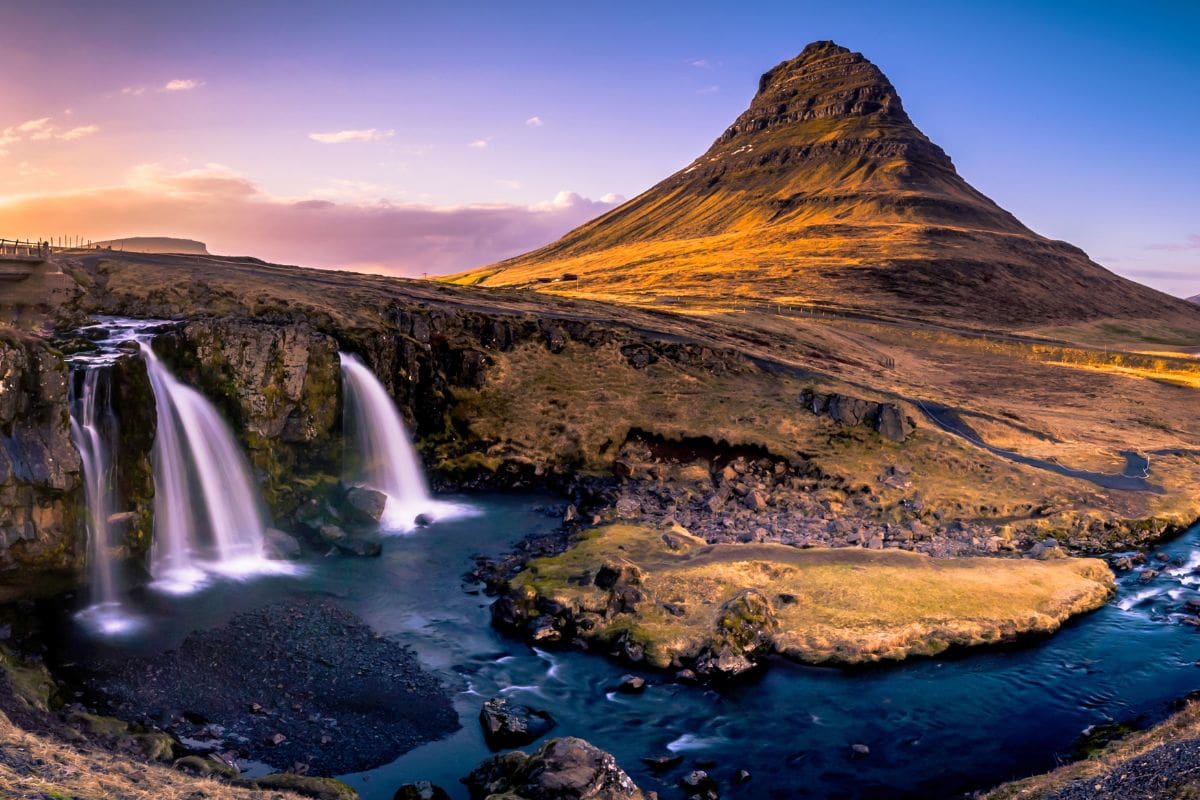
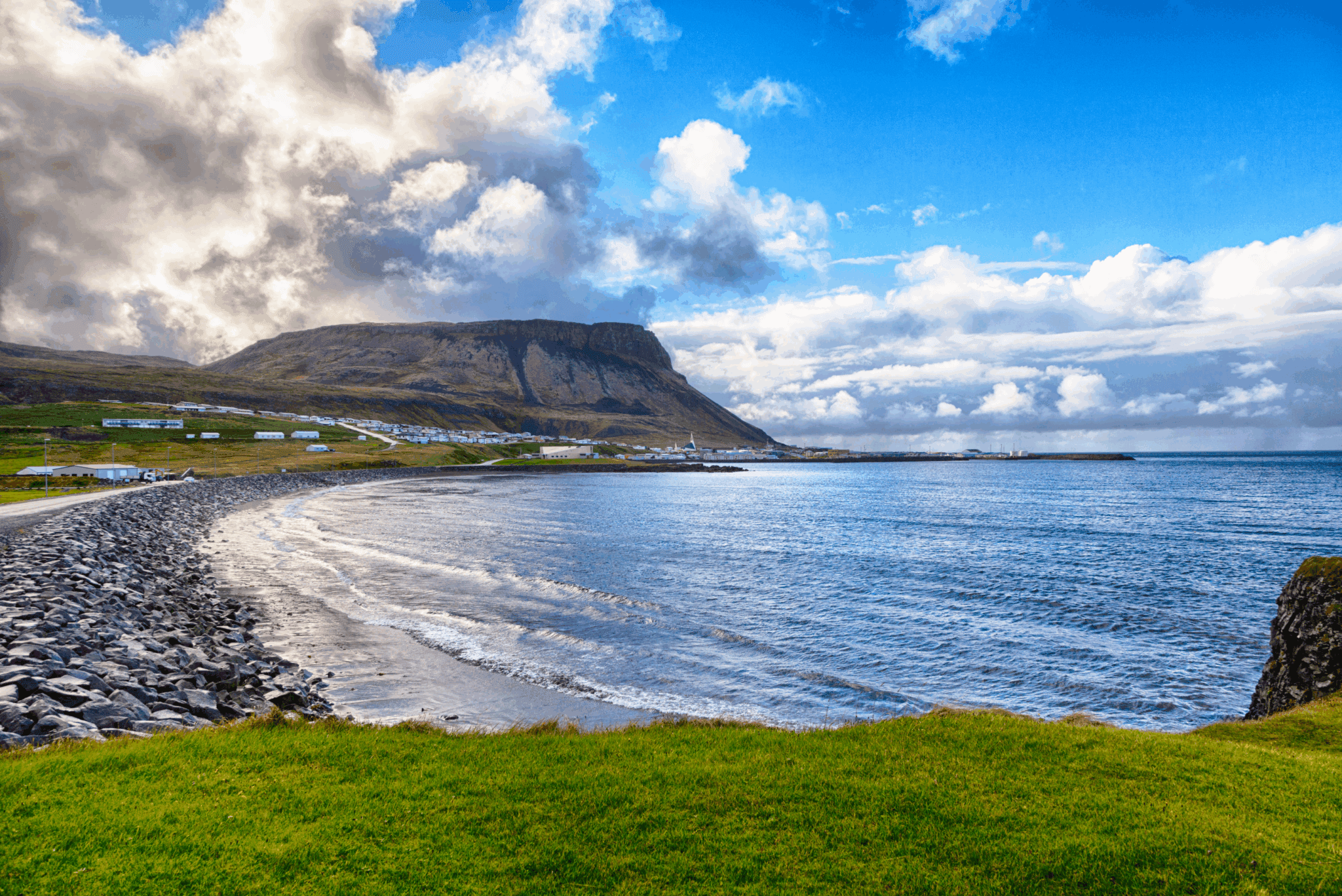
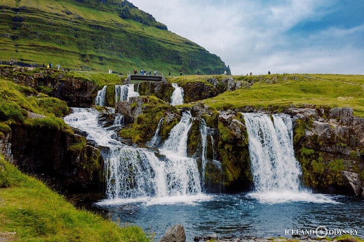
La cittadina di Grundarfjörður has a population of a little under 900 people. It is one of the five communities of Snæfellsnes that in 2020 received a Platinum Certification di EarthCheck for environmental destination standards, confirming the Snæfellsnes region is an environmentally conscious community. Hovering over this fishing town is the 463 m (1,519 ft) mountain Kirkjufell (e. Church Mountain) known by fans of Il Trono di Spade as the Montagna della punta della freccia in seasons 6 and 7, making it the main attraction and landmark of Grundarfjörður. Kirkjufell has been referred to as the most beautiful mountain in Iceland and is believed to be the most photographed mountain of them all.
Kirkjufell gives its name to the small Kirkjufellsfoss waterfall, which is often photographed as the foreground of Kirkjufell. It runs down the river Kirkjufellsá, creating three waterfalls all bearing the same name.
The little fishing village Ólafsvík is an old market town with a population of about 1,000 people. It was one of the larger trading posts of the 17th and 18th centuries in Iceland, being a commercial vessel between Denmark and Iceland, and was the first town in Iceland to receive commercial rights from the Kingdom of Denmark. In the town center stands an old warehouse constructed in 1844, which now serves as a museum and an information center. Called Pakkhúsið, it is among the few last standing business premises built in the 19th century and is a monument representing the town’s past and history. We highly recommend making a stop for lunch at our favorite restaurant in Ólafsvík to try their delicious fish courses with freshly caught fish (they also have great vegan options).
A short drive out of Ólafsvík is the beautiful 10 m (33 ft) high Svöðufoss waterfall, falling off a basalt columned cliff. From the parking lot is a short walk to a resting area with a viewing platform to admire Svöðufoss.
Skarðsvík bay has a beautiful secluded golden sand beach surrounded by deep black fractured basalt columns, and the depth combined with the bright clean ocean makes it aquamarine-colored. Icelanders are more used to black sand beaches all around Iceland, so this beach makes for a change. Though the waves are not as strong and forceful as the ones by the Spiaggia di sabbia nera di Reynisfjara sulla Costa Sud, we still advise to not go too close to the waterline. A wooden path from the parking lot makes a short walk to the golden Skarðsvík beach.
In 1962 a heathen burial mound, believed to be from the late 10th century, was found shortly above the tideline. It was of a young male around the age of 14 and in his grave were his sword, a spearhead, and other grave goods. His remains were taken to the Museo nazionale d'Islanda for preservation, but an information sign is on-site at the northern end of the beach where the burial mound was discovered.
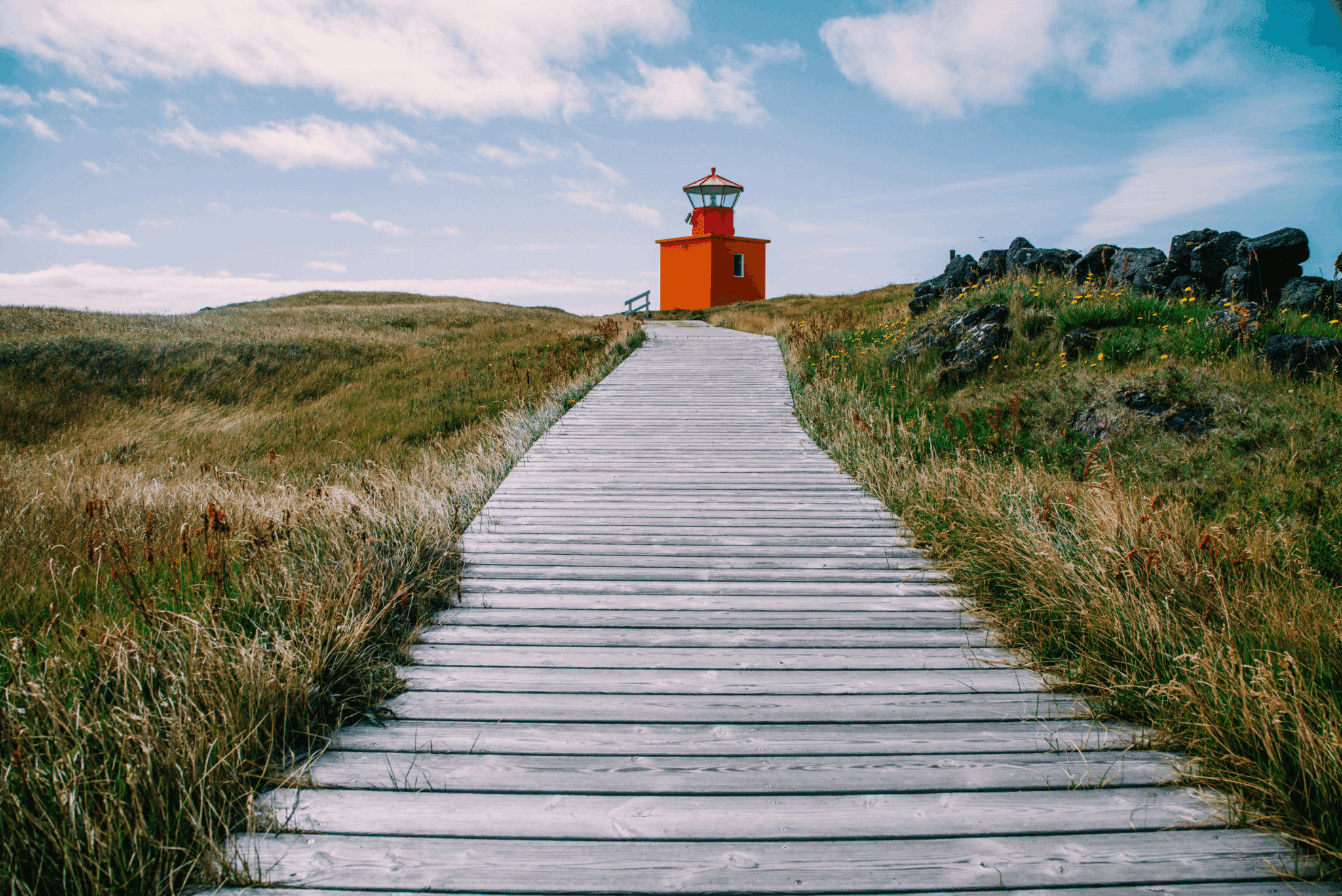
Öndverðarnes cape is the westernmost point of the Snæfellsnes peninsula which used to be an old fishing station from the 13th century into the 20th, with a chapel on-site and a lot of huts for the fishermen. There are a lot of old relics and ruins from ancient times and a deep partly covered stone well called Fálki (e. Falcon – mistakenly called Faxi by some) which can be entered by 18 steps of stone leading down. Fálki used to be the only waterhole in the area it was believed to contain three sources of water; one with freshwater, another with mineral water, and the third with saltwater. The small and orange-colored Öndverðarnesviti standing 5 m (16 ft) tall, was built in 1973 but before was another lighthouse built in 1909 which was the first lighthouse on the Snæfellsnes peninsula.
South of the Öndverðarnes lighthouse is another orange lighthouse built in 1939 by a cliff that used to have a stone bridge attached to the sea rock Skálasnagi, creating an arch before that bridge collapsed in 1973. What is unique about this 12 m (39 ft) high lighthouse is it bears two names; Svörtuloftaviti when you are out at sea, and Skálasnagaviti on land. Another lighthouse used to stand there, built in 1914, but it collapsed after the ocean waves had eroded the cliff. The rugged cliffside along the coastline between these two lighthouses is called Svörtuloft (e. Soffitti Neri). The pitch-black lava cliffs are very steep and sharp and a lot of ships and boats have shattered to pieces when crashing these cliffs in extreme weather, leaving no survivors. The last shipwreck happened in 2001, leaving one survivor of four.
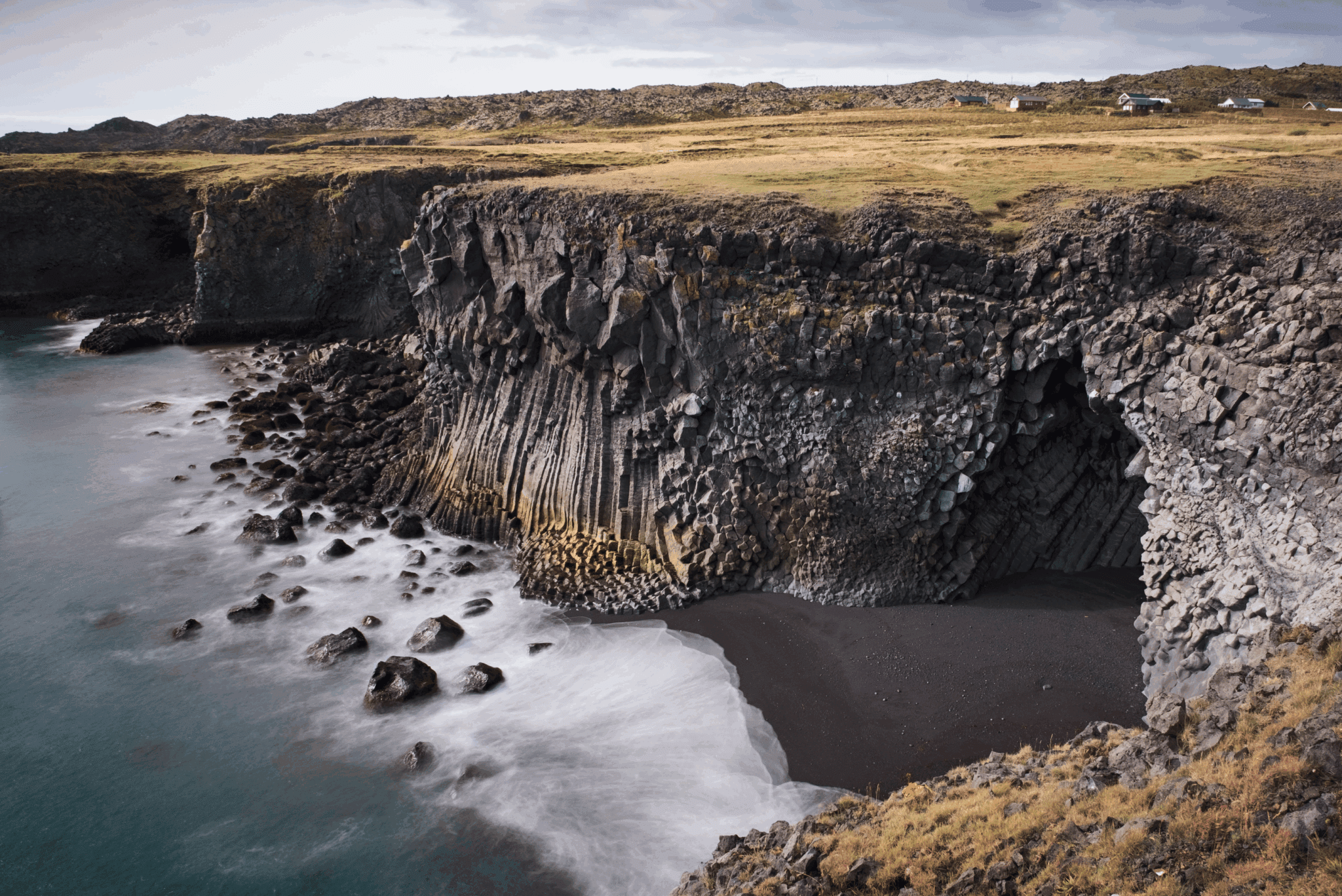
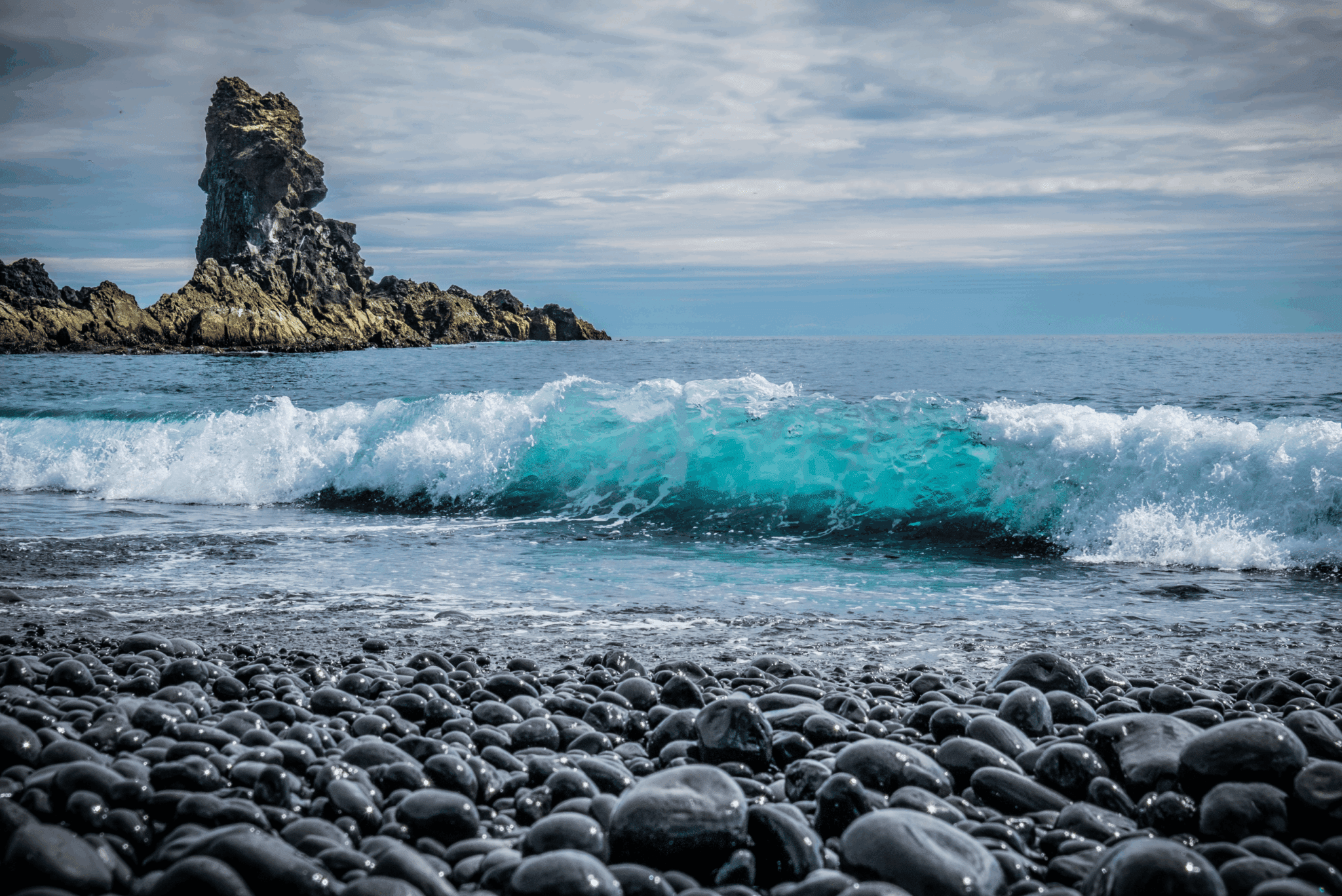
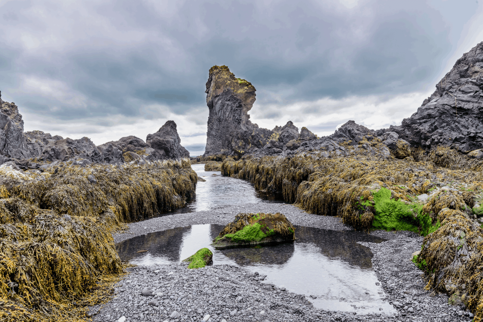
A short walk through a lava field down Nautastígur (e. Bulls’ Path) takes you to the black beach Djúpalónssandur (e. Sand of Djúpalón). It’s not a beach of sand but black smooth pebbles referred to as Djúpalónsperlur (e. Pearls of Djúpalón). These pebbles are protected so you are only to admire them and not take any away with you. Behind Nautastígur are do small loons called Djúpalón (e. Deep Lagoon) and Neðra-Lón (e. Lower Lagoon), which the beach derives its name from. By them are four lifting stones in different sizes called Aflraunasteinar (e. Test of Strenght Stones), used to measure the strength of fishermen who wanted to earn their spot on fishing boats. These lifting stones are: Amlóði 23 kg / 51 lbs (e. Weakling), Hálfdrættingur 54 kg / 119 lbs (e. Half a Man), Hálfsterkur 100 kg / 220 lbs (e. Half Strong), Fullsterkur 154 kg / 339 lbs (e. Fully Strong). If a fisherman could lift Hálfdrættingur, he was accepted on board.
Scattered around the beach are iron remains from the shipwreck Epine GY7, a British fishing trawler that wrecked in a severe storm east of the creek Dritvík in 1948. Only five men of the 19 men on board were saved. In memory of these brave English fishermen, these remains are kept on the beach and are not to be removed.
Further down the beach is a reddish lava rock called Söngklettur (e. Singing Rock), said to be an elves’ church. Alongside the beach next to the cliffs is a lava rock called Kerling (e. Old Lady), said to have been a female troll carrying a bundle of fish on her back when turning into a rock when she got caught by sunlight. Please admire this area carefully and mind the waves, since a “sneaker wave” might snatch you if you stand too close and pull you out.
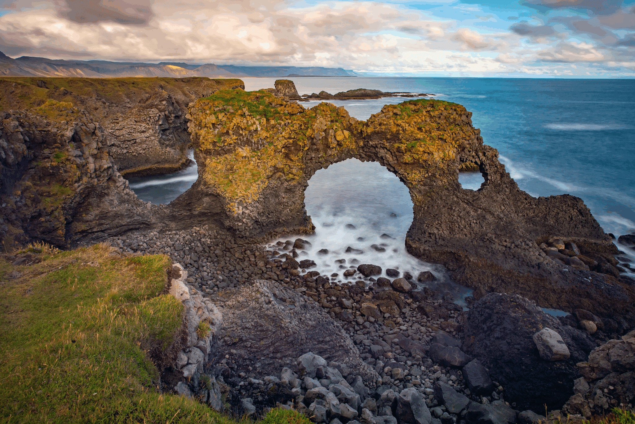
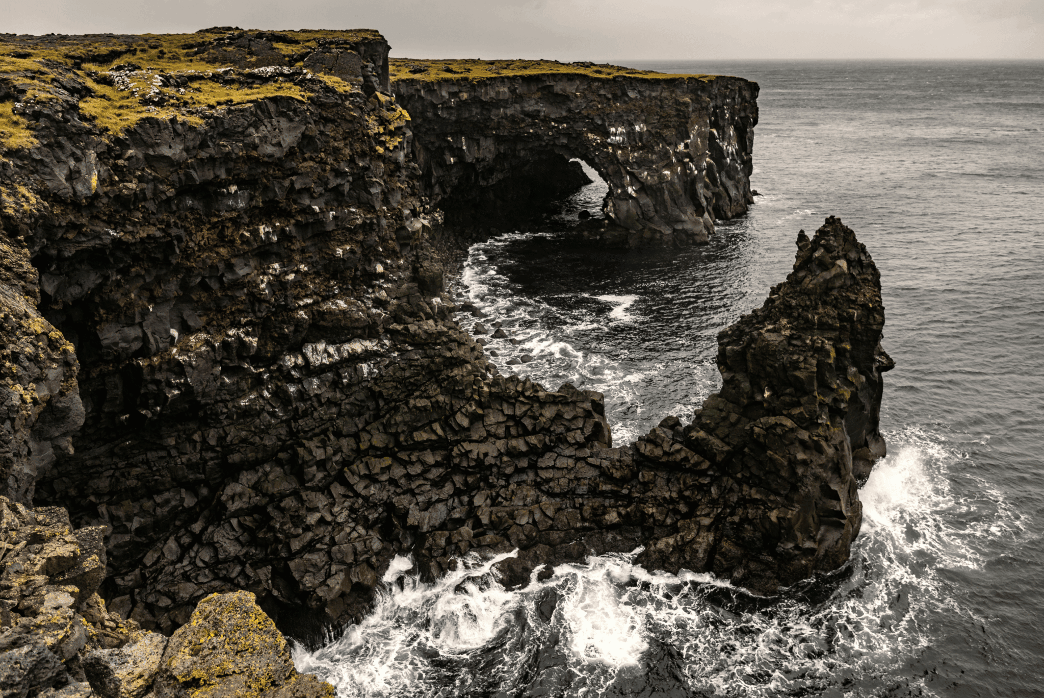
Two rock pinnacles stand tall just out of the shore called Lóndrangar (e. Lagoon’s Pillars), 61 m (200 ft) and 75 m (264 ft) high. One of the pinnacles is believed to be an elves’ church and the other to be their library. Due to the cliffs by the shore being so dangerous, an observation platform was constructed by ←úfubjarg e Svalþúfa for a view of Lóndrangar in distance. Þúfubjarg is a cliff that is home to various sea birds nesting, standing beneath the palagonite headland Svalþúfa. It is forbidden to mow the grass on Svalþúfa as it is believed to be inhabited by elves.
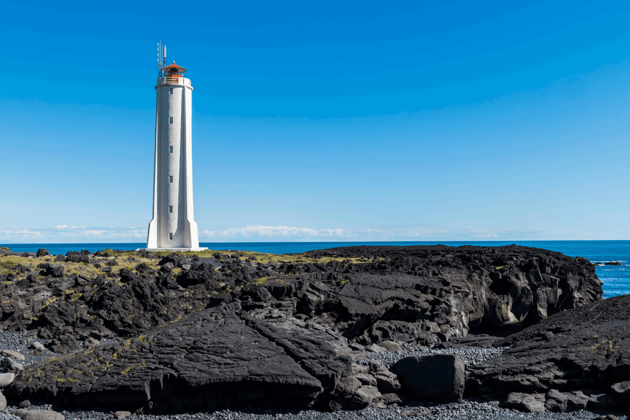
From the observation platform, you see over to the reef Malarrif where the 24 m (74 ft) high lighthouse Malarrifsviti stands tall. Built in 1946, it is a white cylindrical tower with a red lantern house on top. For centuries, Malarrif was a fishery until 1900 and then a farm till 1997 which now is abandoned.
The fishing villages Hellnar e Arnarstapi are commonly referred to as twin villages.
Hellnar was among the largest fishing station on the Snæfellsnes peninsula, dating back to 1560. Having about 200 residents living there in 1703, with 38 buildings functioning as farms and lodgings and structures related to the fishery, times have changed since then. Now a lot fewer people live there, with a hotel and a little café being operated there. The café is by Hellnafjara (e. Shore of Hellnar) and is popular for the location and view it offers from its patio over beautiful rock formations by the sea. Locals often walk a 2.5 km (1.55 mi) route by the coast over Hellnahraun (e. Lava Field of Hellnar) to Arnarstapi, starting from this little café in Hellnar. Behind the café is a statue of the Virgin Mary by a holy spring called Maríulind (e. Spring of Mary), formerly called Gvendarbrunnur (e. Spring of Guðmundur) in reference to the bishop Guðmundur Arason nicknamed hinn góði (e. the good). He is believed to have consecrated the spring in the 13th century, making it have healing powers. In front of the café by the shore is the protruding boulder Valasnoti with an opening and a cave called Baðstofa (e. Sitting Room), very unique for the coloration inside that forms due to the tides and different lighting and its walls being made of schist rocks which is a type of rocks that look like flakes or scales. Schists were sometimes used as tiles on the roofs of turf houses in some parts of Iceland. Closeby is the abandoned farm Laugarbrekka which used to be a church estate till the church was moved to Hellnar in 1883. The current standing church Hellnakirkja in Hellnar was built in 1946 instead of the former turf church. Laugarbrekka is the birthplace of Guðríður Þorbjarnardóttir, born in AD 980, who was an Icelandic explorer. She was called Guðríður víðförla, meaning the widely traveled. At the age of 20, she moved with her father to Greenland to accompany Eiríður rauði (Eirik the Red), the father of Leifur Eiríksson (Leif the Lucky). Guðríður married Þorfinnur Karlsefni and together they led an expedition to Vínland where she gave birth to their son Snorri Þorfinnsson, making him the first European being born in the Americas. This pre-Columbian Norse exploration by the Vikings of the mainland of North America is mentioned in the Icelandic Sagas e il Vinland Sagas.
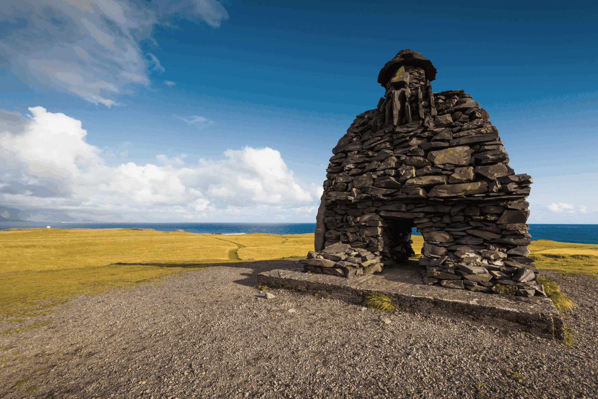
Arnarstapi (also referred to as Stapi) is a small fishing village with unique rock formations along the coastline, making it look like an artwork of nature, and the cliffs are filled with sea birds during the breeding season. Arnarstapi was a natural site for landings, making it ideal as a fishing port, so early on it was a busy fishing and trading port. From 1565 through the 18th century, Danish agents had custodial power over Arnarstapi and commercial rights under the Regno di Danimarca. A few old houses from the 18th century are still in Arnarstapi. During summers the harbor is busy serving private fishing and recreational vessels and is a thriving destination for tourism. When coming to Arnarstapi you will be greeted by a huge rock statue of Bárður Snæfellsás made by Ragnar Kjartansson. He is a half-man half-troll who was the first settler of Snæfellsnes who gave this peninsula its name. The story Bárðar Saga Snæfelssás tells of a terrible family tragedy related to Bárður and the settlers of Snæfellsnes. Helga was Bárður’s oldest daughter of his 9 daughters, and one day she was playing with her cousins Rauðfeldur e Sölvi, sons of Bárður’s half-brother Þorkell, by a beach when they pushed Helga onto an iceberg that drifted away to Greenland. Bárður got so angry he took the brothers under both arms and headed to the mountains where he threw Rauðfeldur into the Rauðfeldsgjá gorge and Sölvi over the cliff Sölvahamar, killing both instantly. Hearing the news of his sons, Þorkell fought Bárður who broke his leg and left him on the ground. Þorkell moved away and Bárður took all his belongings and headed to the Snæfellsjökull glacier, where he is believed to have disappeared into the glacier. On the Snæfellsnes peninsula are a lot of locations bearing names in reference to Bárður Snæfellsás. After this tragedy, Bárður has been regarded as the guardian of the Snæfellsnes peninsula.
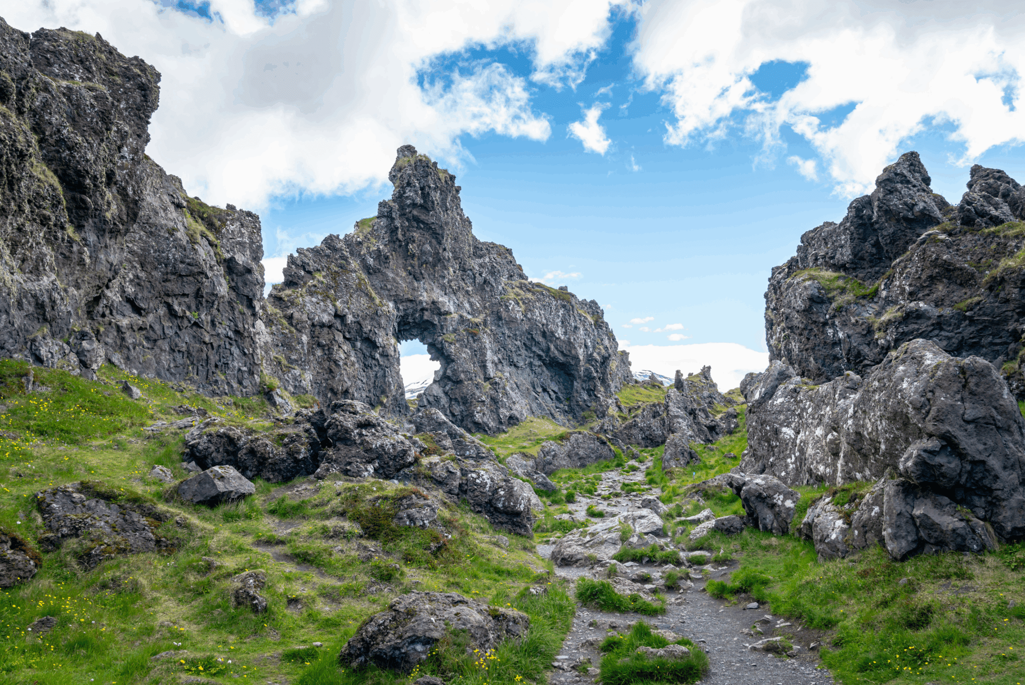
A walking trail runs from the statue of Bárður along the coastline where you will see many of the amazing formations aforementioned; lava and basalt cliffs, vaults, and ravines eroded by waves for centuries. From the first observation platform, you will see basaltic caves beneath and a beautiful view over the Oceano Atlantico. Going onto the next platform gives you a great view of Gatklettur, a rock arch with a big hole in it, extending from the basaltic cliffs. Walking further you will reach the first of three ravines, which are like holes in the ground by the coastline. It’s tempting to have a look down these ravines at the sea coming in, but please watch your steps and be careful so as not to fall into them. These ravines are collectively named Stapagjár (e. Ravines of Stapi) but individually they are called Norðurgjá (e. The North Ravine), Miðgjá (e. The Middle Ravine), e Músagjá (e. The Mousy Ravine). On days when the weather is bad and waves are strong, you may see the surf splashing up into the air from these ravines. The stone bridges by these ravines attract people to walk over for great photo opportunities but keep in mind they could collapse at some point. Next to one of these ravines is Arnarstapaviti, a white square lighthouse 3 m (9.8 ft) tall. Standing next to the Snæfellsjökull glacier, hovering over Arnarstapi, is the peculiar 526 m (1,725 ft) high Stapafell which is a palagonite volcano. From some angles, it looks like it’s shaped like a pyramid.
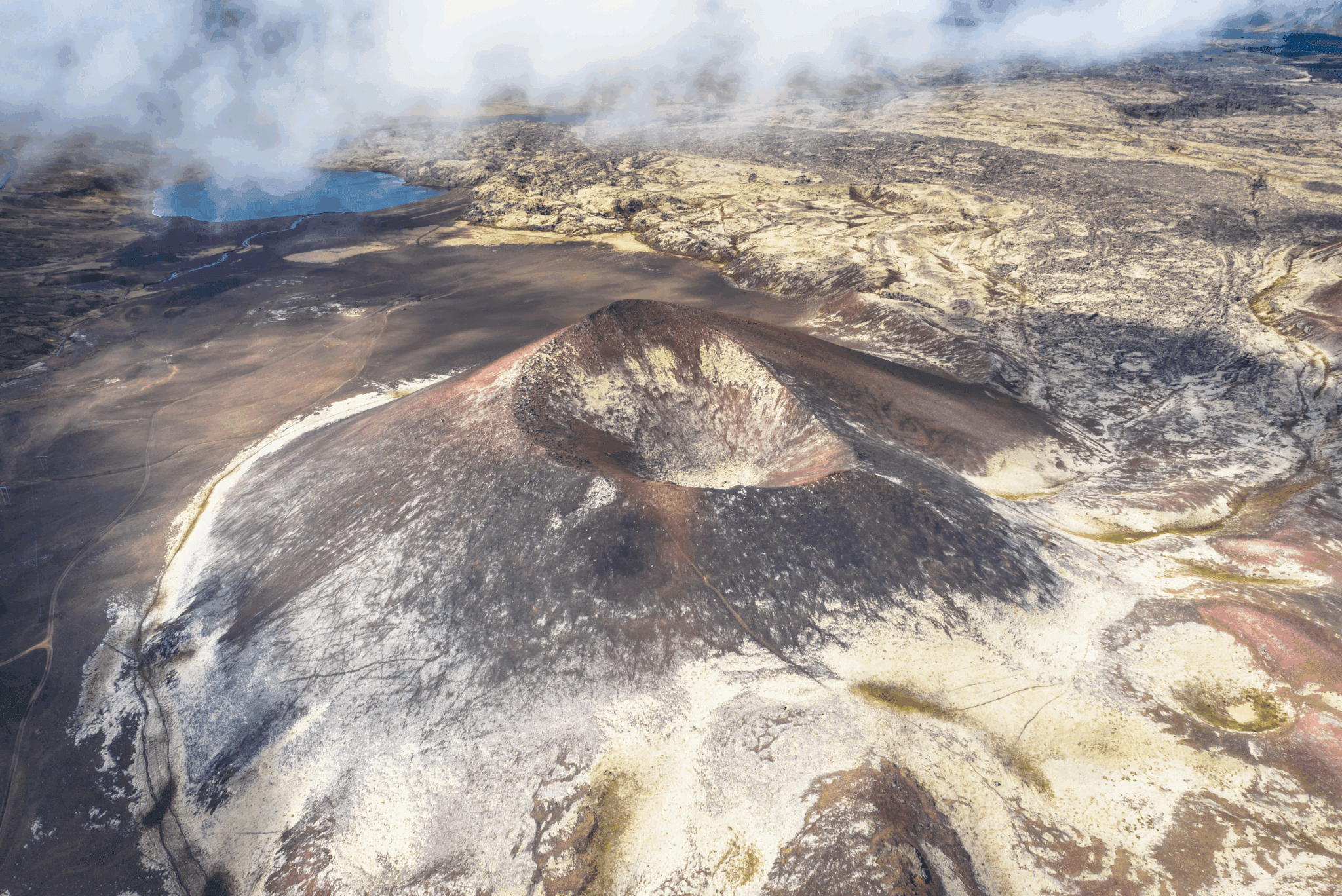
The very small village of Búðir is a popular destination for visitors. Situated in Búðahraun (e. Lava Field of Búðir), it is believed to have been the landing of fishing and commercial ships since Iceland was settled, functioning mainly as the commercial and trading post of Snæfellsnes and the west coast region during the Danish trade monopoly. Búðahraun has been a protected area since 1977, originating from the eruption of Búðaklettur, a 88 m (289 ft) high scoria crater standing in the middle of the lava field, believed to have erupted 5,000-8,000 years ago. This pitch-black lava field is unique for the vegetation growing there, having 11 birch species of 16 in Iceland growing in the field. The eastern part of this lava field is pahoehoe lava which contains a lot of caves, fissures, and holes and some of them are visible while the others are covered in moss and vegetation. The sand on the shore by Búðir is almost exclusively composed of olivine grains, which is very rare, and since olivine is green the sand is somewhat green-yellowish in color. One of the most photographed churches of Iceland is the black wooden Búðakirkja (e. Church of Búðir), along with its graveyard. People from all over the world come to seal their love in this church, but like most churches in Iceland, it is not open to the public visiting due to more vandalism happening. But this is not the original church, but a replica built in 1987 of the former one which was built in 1848. The first church at Búðir was built in 1703 and churches have been rebuilt there several times since. Búðakirkja is the only reminder of the vibrant fishing village Búðir used to be until the 19th century. The first hotel in Búðir, called Hotel Búðir, was built in 1947, but unfortunately, it burned down to the ground in 2001. A new hotel was built shortly after in the same image as the older one and is a very beautiful and popular hotel to stay at.
On the way to Búðir, you will pass a farm called Öxl (e. Shoulder). It is the former home of the first AND only serial killer in Iceland, who lived in the 16th century; Björn Pétursson nicknamed Axlar-Björn. The most reliable documentation tells that Björn murdered 9 people with an axe, while various folklore says the number ranges from 14 to 19 people. His victims were mostly travelers passing by his farm, who Björn robbed and then killed, digging their bodies in the cowshed (while folklore tells he put their bodies into the pond Íglutjörn by his farm). Björn was arrested in 1596 after a traveler managed to escape and tell on him. Björn was found guilty and sentenced to death for his crimes at Laugarbrekkuþing (e. Assembly of Laugarbrekka). More bodies were discovered in the Búðarhraun lava field on Björn’s land but he denied having killed them and claimed he had found them dead and kept their belongings. His execution was gruesome, like most of them were in those days in Iceland; his arms and legs were crushed with a sledgehammer while he was still alive, his head then cut off with an axe, and his body cut down for the body parts to be put up on poles. He was then buried in three separate graves marked with cairns of heaped-up stones in the land of Laugarholt by Hellnar to prevent him from returning as a ghost and haunting the living who were still afraid of him. Only one of these cairns still stands over one of his burial mounds, called Dreplakolludys, while the others were destroyed by road constructions and quarrying in the lava field. Dreplakolludys has now been declared as protected for its historical value.
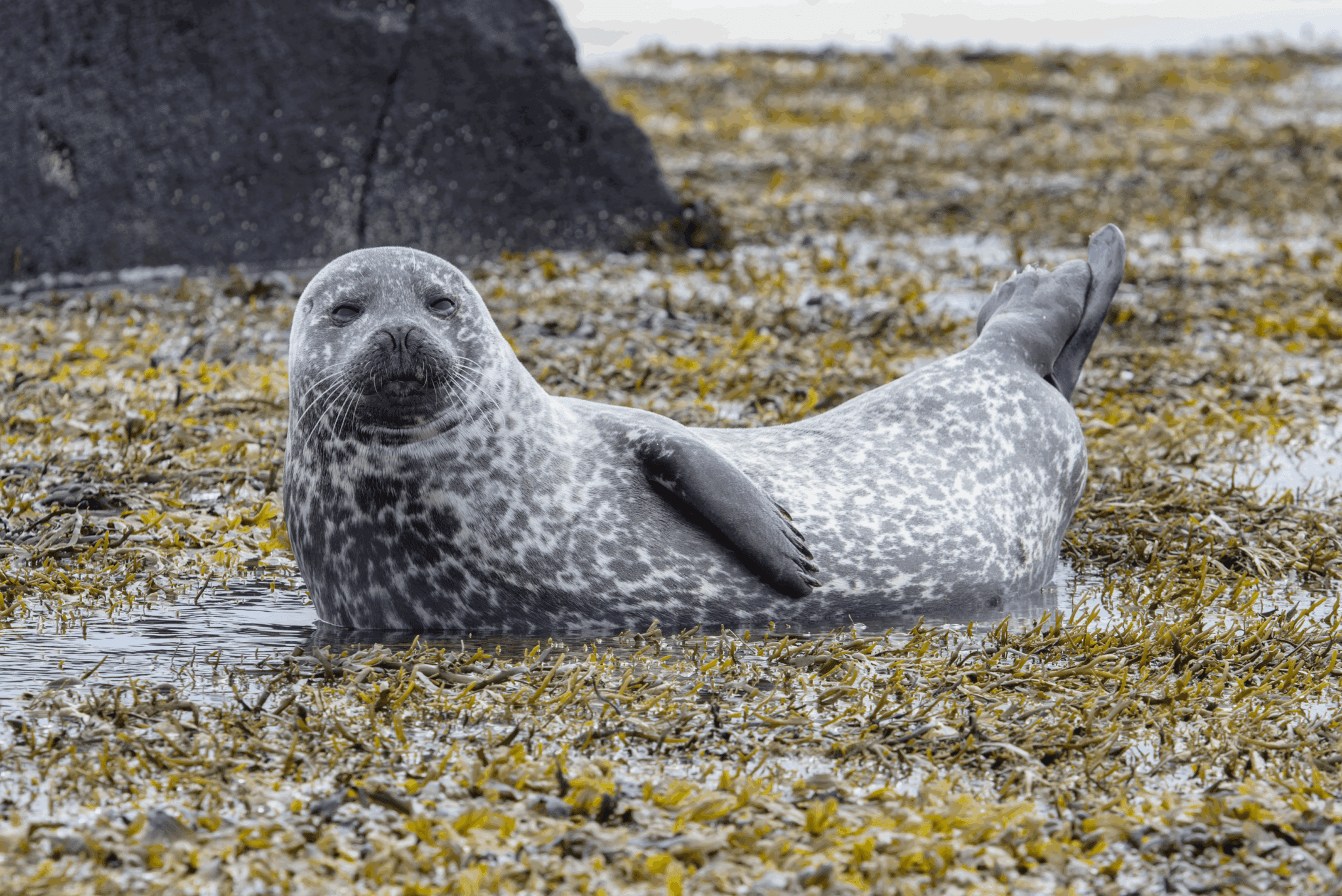
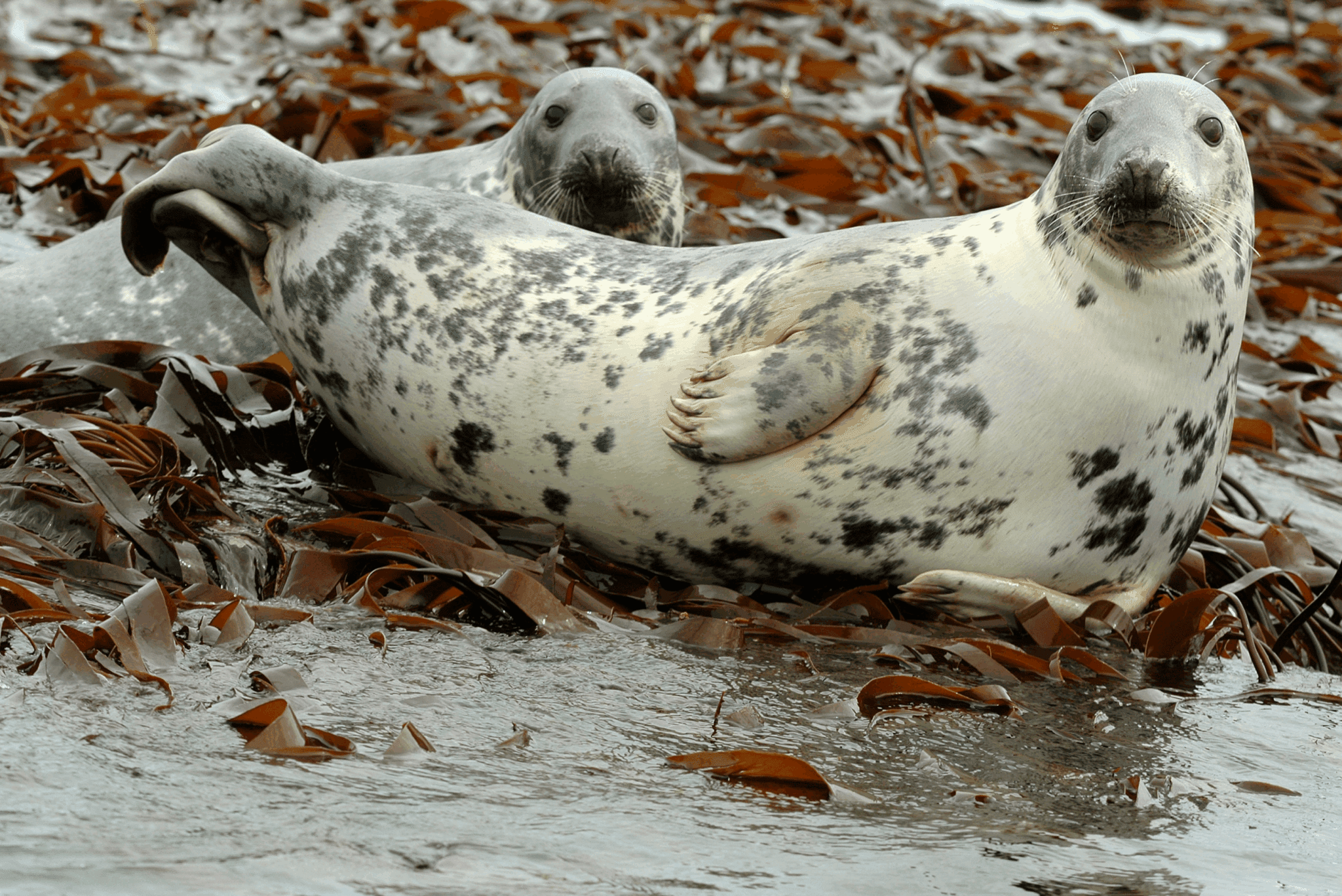
Walking down a path is Ytri-Tunga, a beautiful golden sand beach most known for seal watching. Seals reside there all year, though you are not as likely to spot them during wintertime since the best time is in summer after they pup. The two species residing there are the harbor seal (lat. Phoca vitulina), also known as the common seal, e il grey seal (lat. Halichoerus grypus). The harbor seal is the more common seal specie in Iceland and they are genetically distinct from other harbor seals in the NE Atlantic Ocean. The grey seal is considerably larger than the harbor seal, with a longer flatter head.
Seals used to be vital to Icelanders for survival due to their meat, fat, and waterproof hides but hunting seals is now prohibited in Icelandic territory.
Please remember to not approach the seals and keep a distance of at least 50 m (164 ft) from them, both for you and the seals. They can become dangerous when frightened so keep any noise respectfully low.

199.900 ISK
8.000 ISK
45.000 ISK
328.028 ISK
24.000 ISK
12.000 ISK
34.000 ISK
18.000 ISK
172.830 ISK
18.900 ISK
Consigli di viaggio, nuove guide e un heads-up quando le previsioni dell'aurora sembrano buone Niente spam.