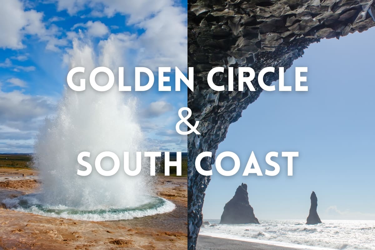
Merveilles de la côte sud avec sources chaudes de Reykjaböð
27.999 ISK
13 heures


Facile
280 000 ISK
Attention:
Le temps peut être imprévisible en Islande, donc en hiver, vous pouvez vous attendre à ce que nous devions occasionnellement modifier l'itinéraire de la visite si les conditions météorologiques et routières sont défavorables.
Disponible: Toute l'année
Durée: Approx. 10hrs, depending on time spent at stops.
Ramassage : Depuis votre hôtel/hébergement dans la région de la capitale Reykjavik.
Faits marquants
The Golden Circle:
The South Coast:
Description
If you have limited time in Iceland, you can combine the most popular attractions during your stay: the classical Cercle d'or et Côte Sud!
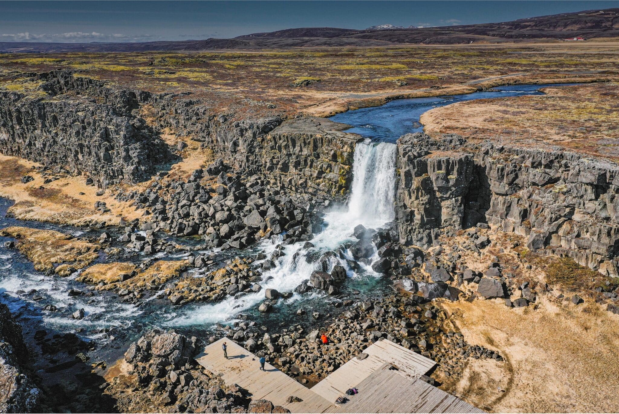
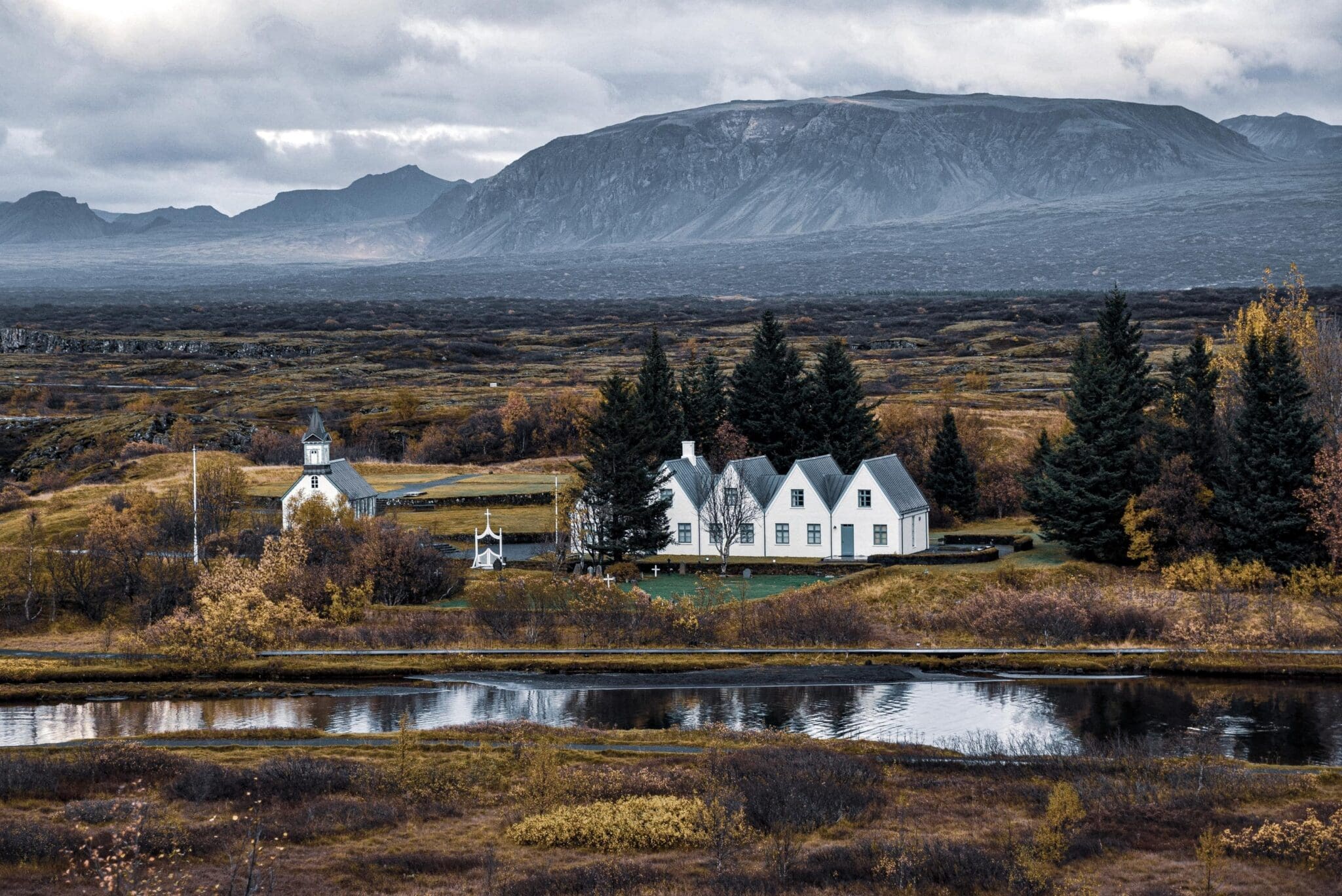
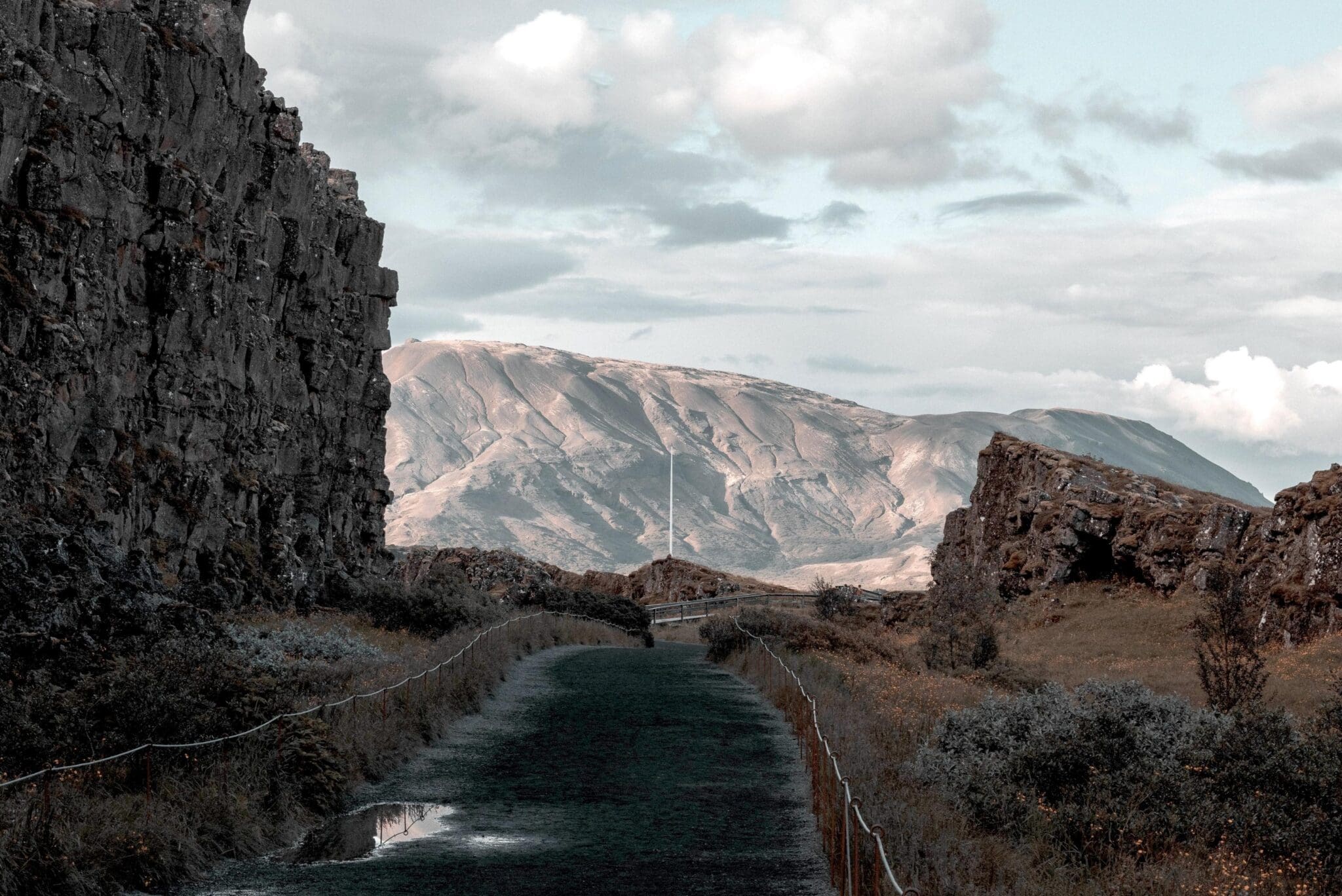
Heading out of the city, you will pass Icelandic farms on the way to the first stop of the tour; Thingvellir Parc National. This is the first national park in Iceland and the first site du patrimoine mondial de l'UNESCO in our country. You will start at Hakið lava mesa, a viewpoint that gives you an amazing view over the Thingvellir area and Thingvallavatn, the largest natural lake in Iceland (about 83.7 square kilometers and 114 meters at its deepest point). You go down from Hakið into Almannagjá by Thingvallabær rectory, today serving as the Prime Minister's summer house, and Thingvallakirkja, a beautiful wooden church representative for common Icelandic churches. In Almannagjá dwells Öxarárfoss, a 12-meter man-made waterfall from when the Vikings changed the course of the Öxará river to channel into Almannagjá, so they could water their horses and sheep when assembling at Althingi each summer, the Icelandic parliament.
Thingvellir may look familiar to you if you're a Jeu de trônes fan, since episodes 1, 5, and 8 of season four were shot here.
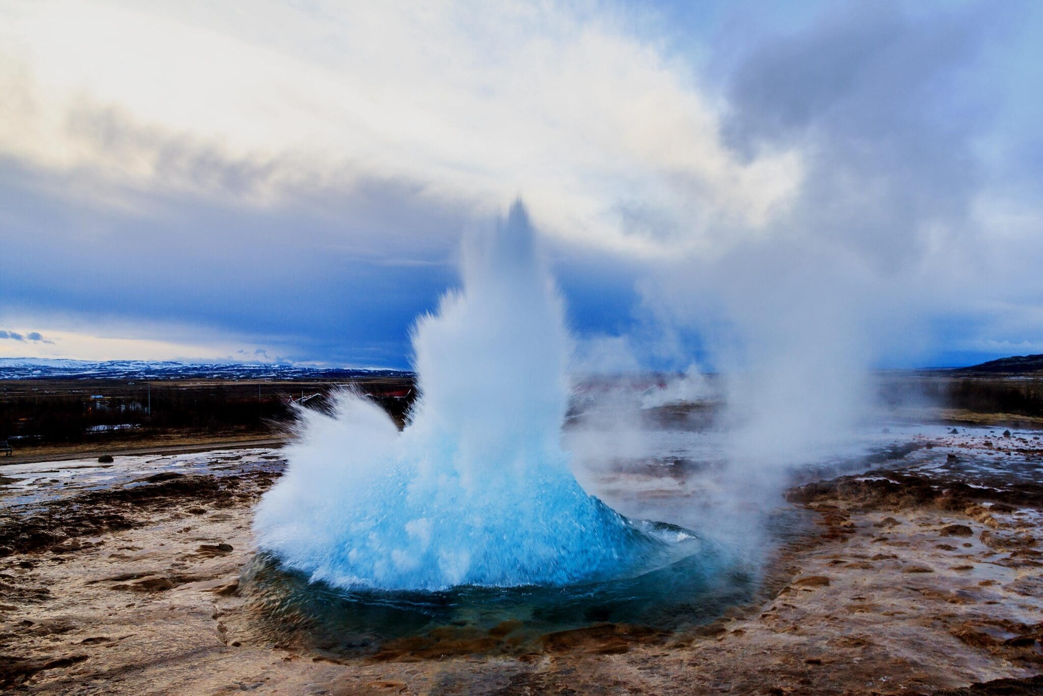
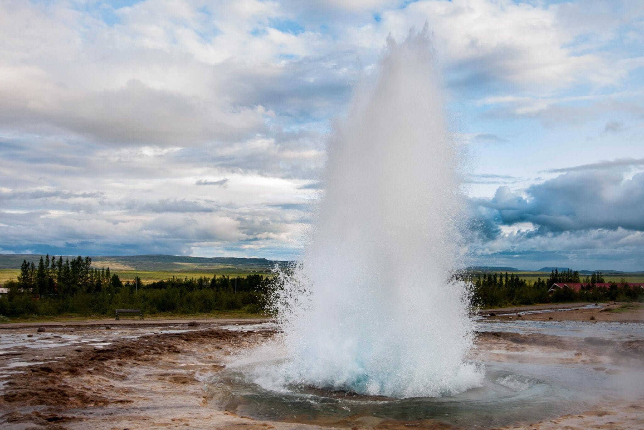
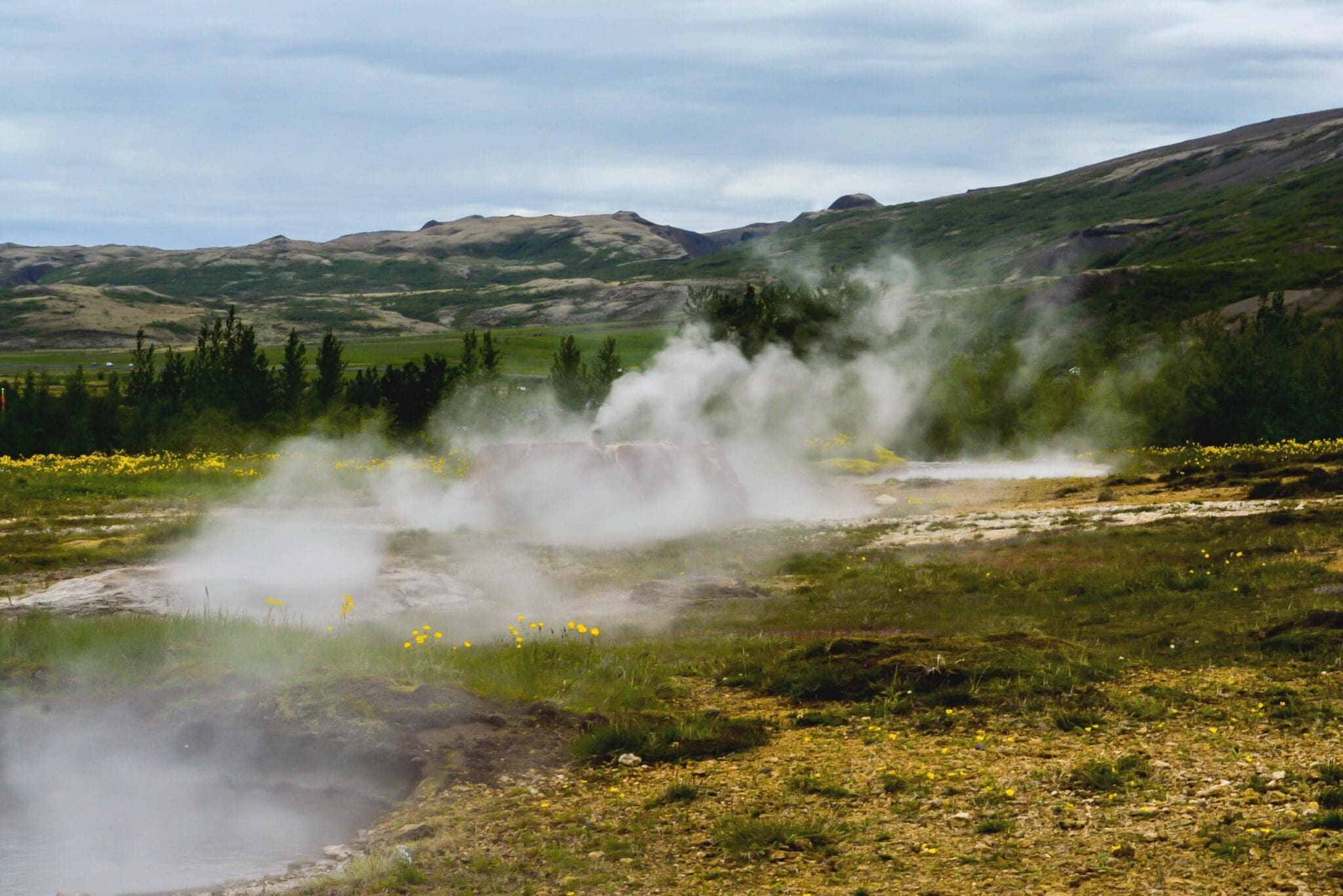
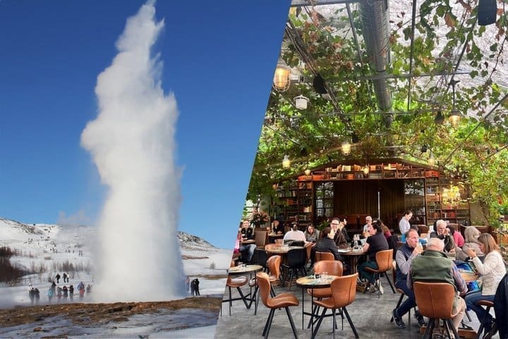
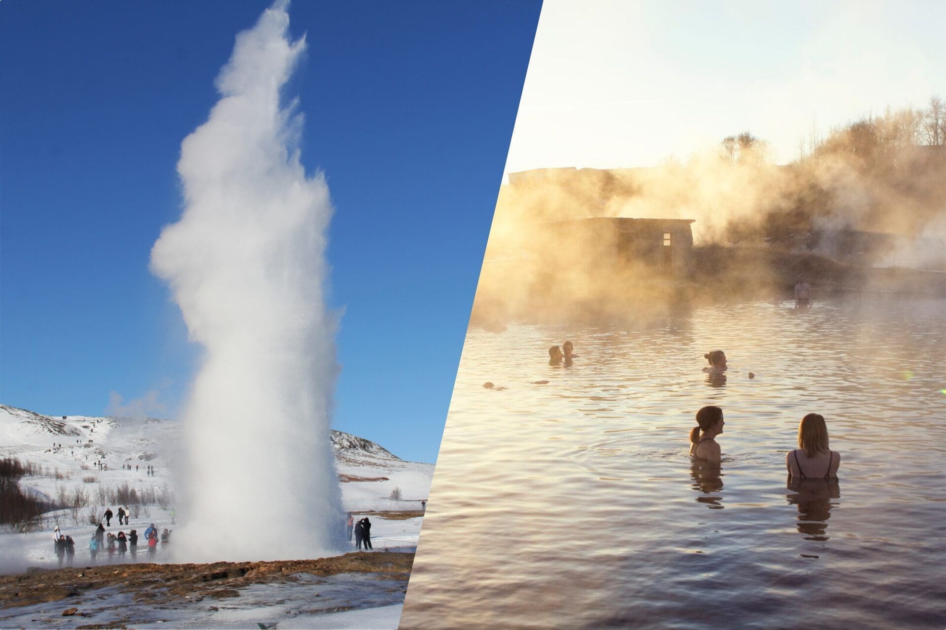
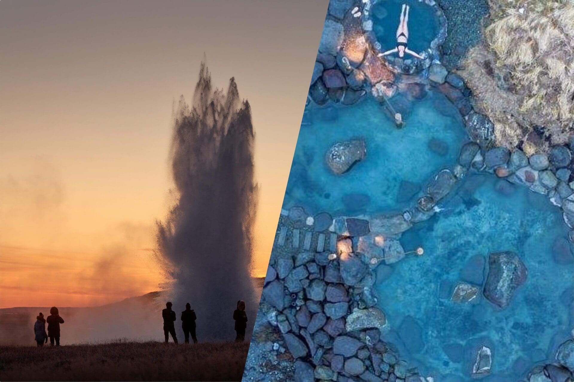
Driving through the wooden Thingvellir National Park, passing more beautiful farmsteads, the next stop is the Geysir zone géothermique des sources chaudes à Haukadalur valley. This high-temperature area with its colorful hot springs and mud pools is the only place in Europe with hot springs that spout. Geysir is Iceland's most well-known geological phenomenon, giving its collective name geyser to all other hot springs in the world. It is dormant and hasn't spouted since 2016, but its neighbor Strokkur still does every 5-8 minutes, shooting 30 meters of scalding geothermal water into the air. Earthquakes in the area and volcanic activity in our country may cause Geysir to awaken and other hot springs in this geothermal area to show changes.
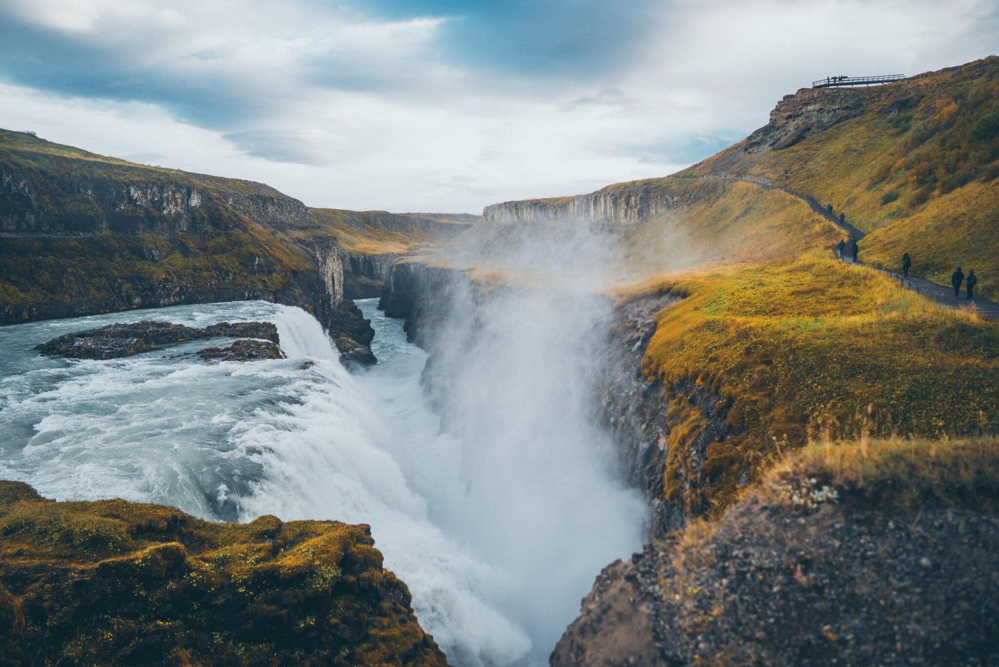
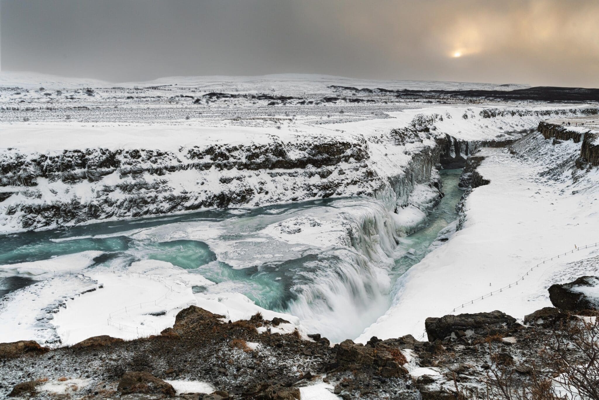
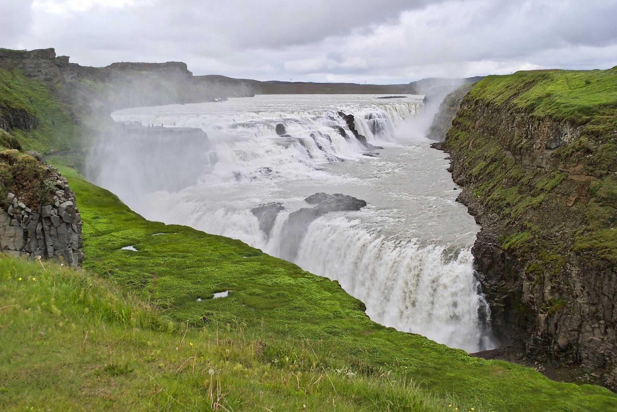
The last stop is what the Golden Circle derives its name from; Gullfoss waterfall, meaning Golden Falls. This magnificent tiered three-step waterfall is considered the queen of all waterfalls in Iceland, plunging 32 meters into a narrow basaltic gorge. The white glacial river Hvita, fed by the Langjökull glacier, gives Gullfoss its white and blueish color, and on sunny days its spraying mist forms a spectacular rainbow, sometimes even a double rainbow.
Driving further south we get closer to the coastline with the Atlantic Ocean on one side and volcanoes and glaciers on the other side, and even the famous Hekla volcano can be seen from the road.
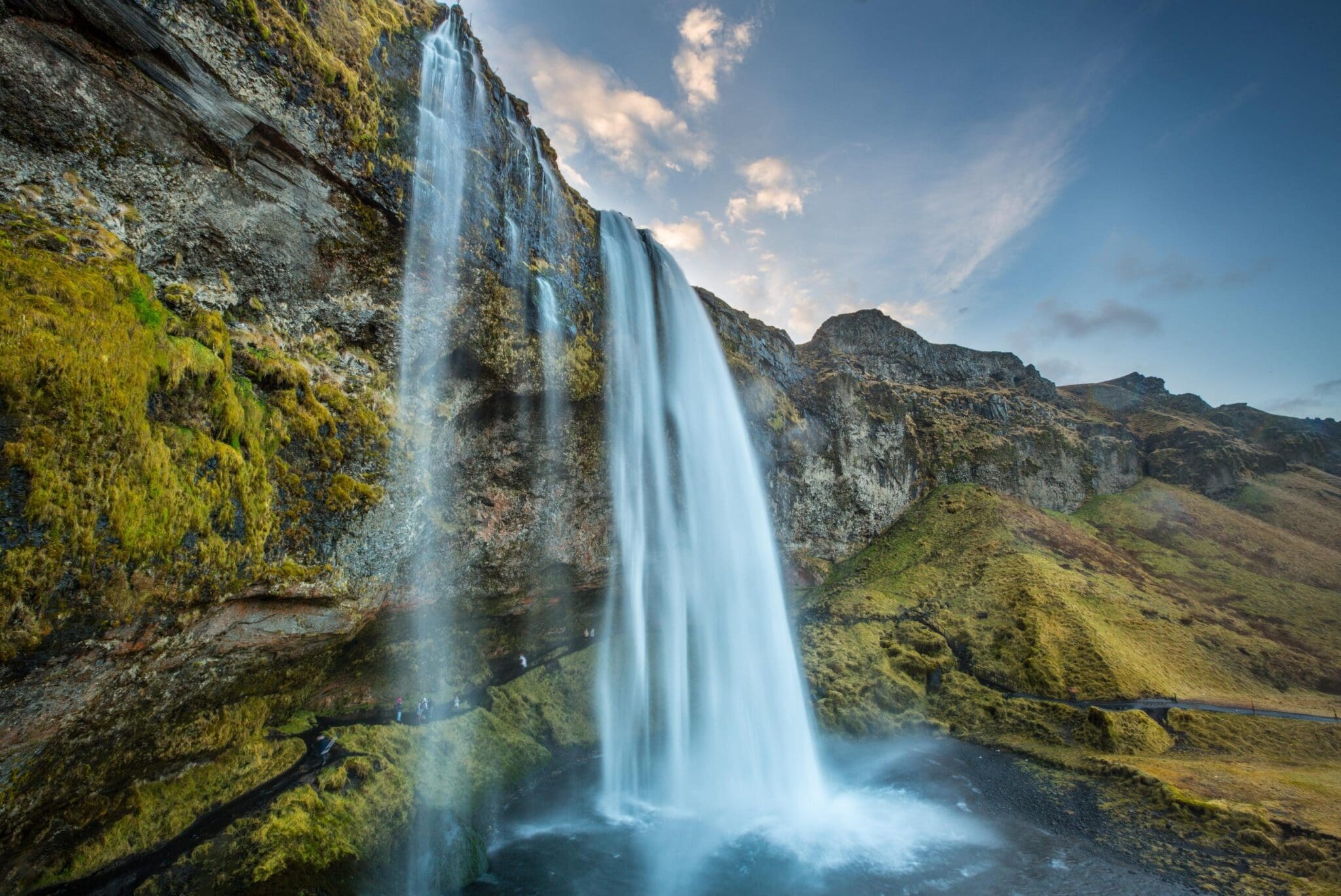
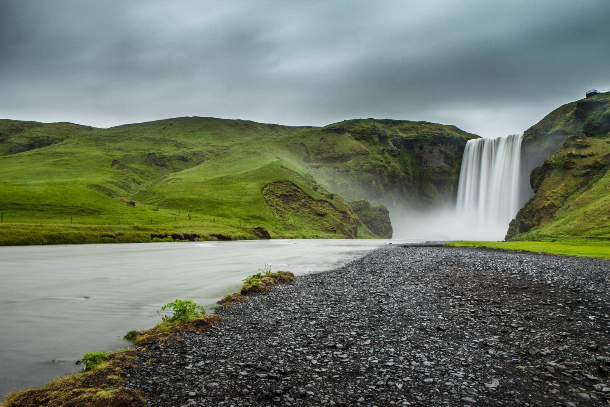
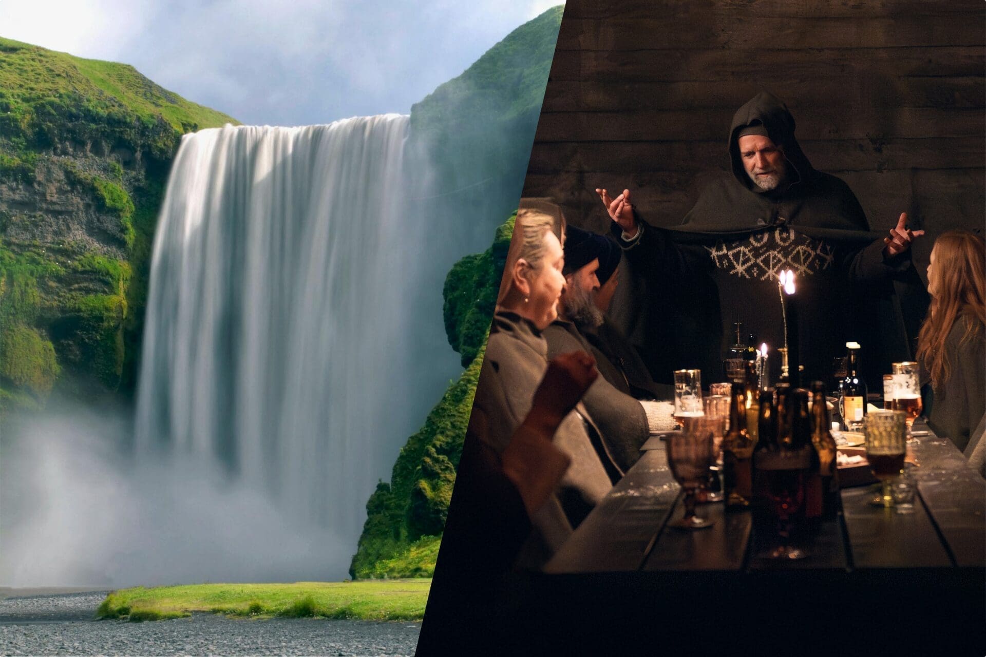
We make our first stop on the South Coast at the unique waterfall Seljalandsfoss, which drops like a curtain off a cliff into a beautiful meadow. Behind is a small cave and a walking path extending around the waterfall. This makes for a great angle to photograph this very picturesque waterfall and its surroundings, but be sure to wear good shoes and waterproof clothing before going behind it. We head on and drive past the ice cap Eyjafjallajökull which covers the caldera of a volcano that last erupted in 2010, memorably affecting air traffic throughout Europe. From the road, you will immediately spot the mesmerizing Skógafoss in the tiny Skógar village. It is one of the most beautiful waterfalls in Iceland dropping wide from a cliff that formerly marked the coastline. If the sun is out, the spraying from Skógafoss will form a rainbow and sometimes two. A staircase next to it leads up to a platform above this waterfall, giving you a great view over farmsteads to the ocean and on-site museums give you insight into how Icelanders lived throughout history.
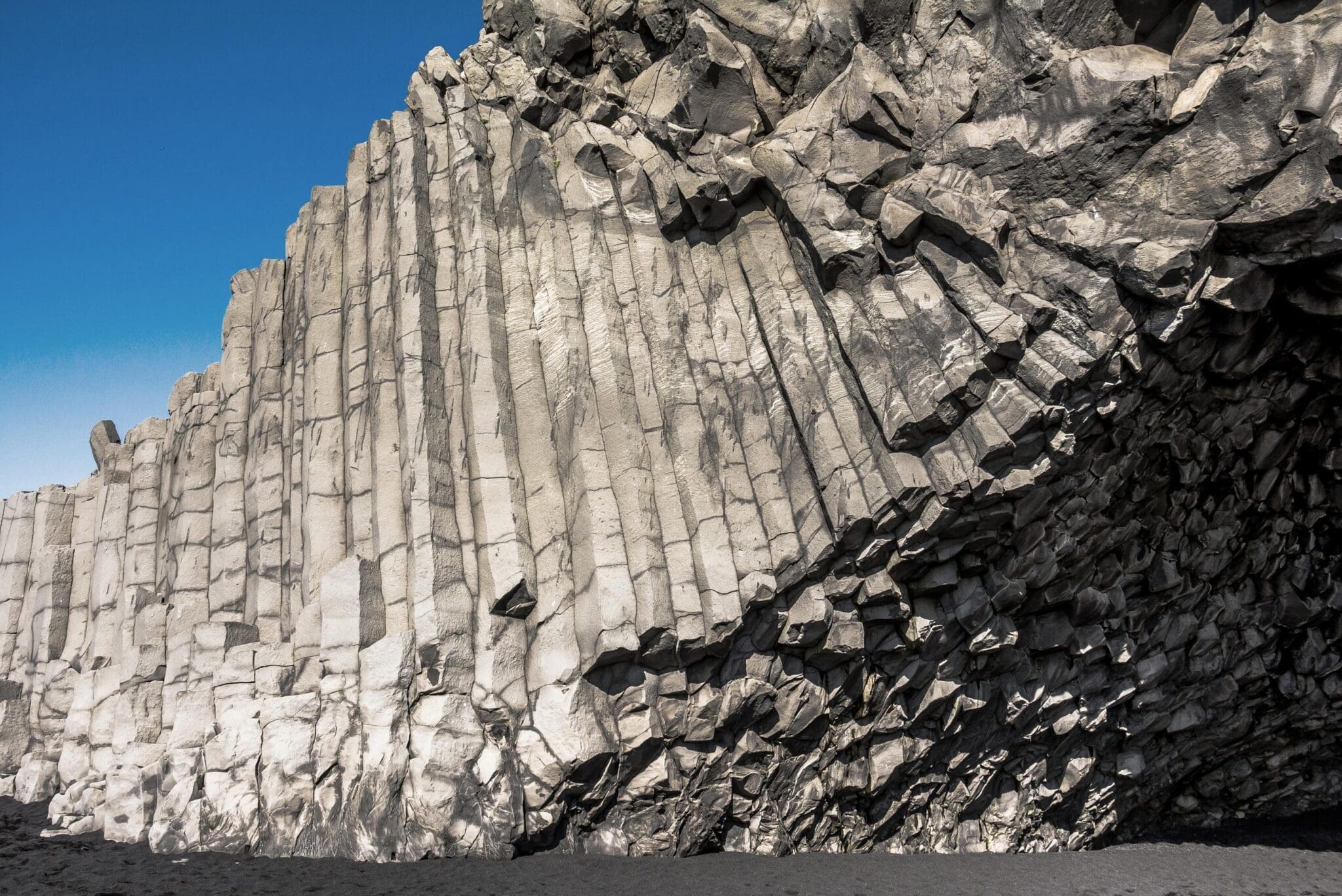
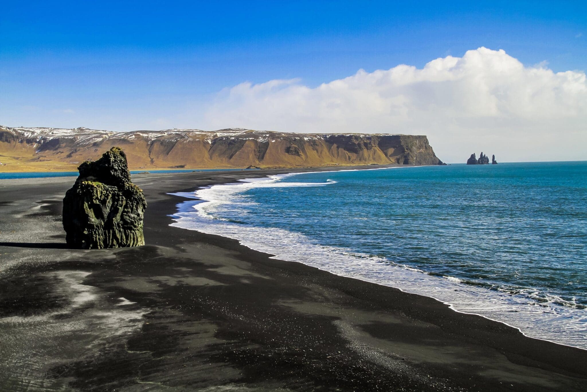
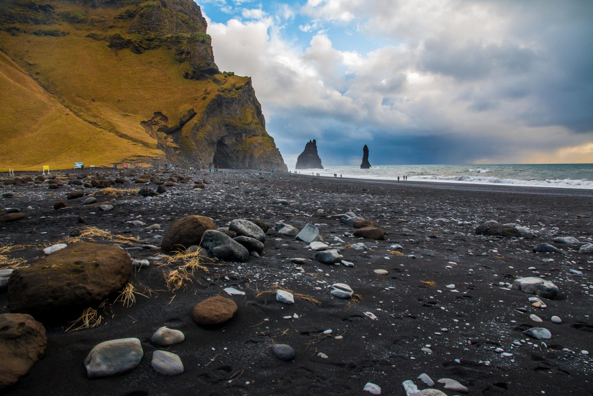
Our last stop is Reynisfjara black sand beach, the most popular visit on the South Coast, with the high basalt pinnacles Reynisdrangar rising out of the sea, and extremely powerful ocean waves crashing against the basalt-columned wall of mountain Reynisfjall and steadily eroding the Hálsanefhellir basalt cave by the beach. Here you need to be extra cautious, as these waves are known as "sneaker waves". Though they may sometimes look calm and harmless, they have snuck up on people and pulled them into the sea, causing fatal tragedies throughout the years when people have gotten too close to the sea. Be careful while admiring this breathtaking area and please respect the puffins and other seabirds nesting in the basalt columns.
After this long day of exceptional landscapes and scenery, we make our way back to the buzzing city life of the Reykjavik Capital Area.
The Thingvellir National Park was established in 1930, the first national park in Iceland. Then in 2004, it became the first site du patrimoine mondial de l'UNESCO in Iceland for its cultural heritage from the Viking era and the significance of its history and nature.
useingvellir (e. Parliament Grounds) is a fracture zone situated on the tectonic plates of the Dorsale médio-atlantique, le North-American and the Eurasian continents, which runs through Iceland from its NE corner to the SW corner, forming a great depression of about 40 km in length and 10 km in width. These boundaries are only visible above ground in very few locations in Iceland. Almannagja (e. Public’s Rift) forms the eastern boundaries of the North-American plate, while Hrafnagjá (e. Raven’s Rift) forms the western bounds of the Eurasian plate. The area between these two rifts is slowly subsiding, pulling apart by about 3-4 millimeters every year.
Alþingi (e. General Assembly) is the Icelandic parliament, established in AD 930 by the Vikings, and is the oldest parliament in the world. Every summer, Icelanders assembled there till 1798 to set laws, settle disputes, trade goods, and carry out punishments and executions. It was at Althingi that the Icelandic nation agreed to adopt Christianity in AD 1000, superseding the heathen religion Asatru. On 17 June 1944, the establishment of the Republic of Iceland was declared in force after centuries of being under the reigns of the Kingdoms of Norway and Denmark.
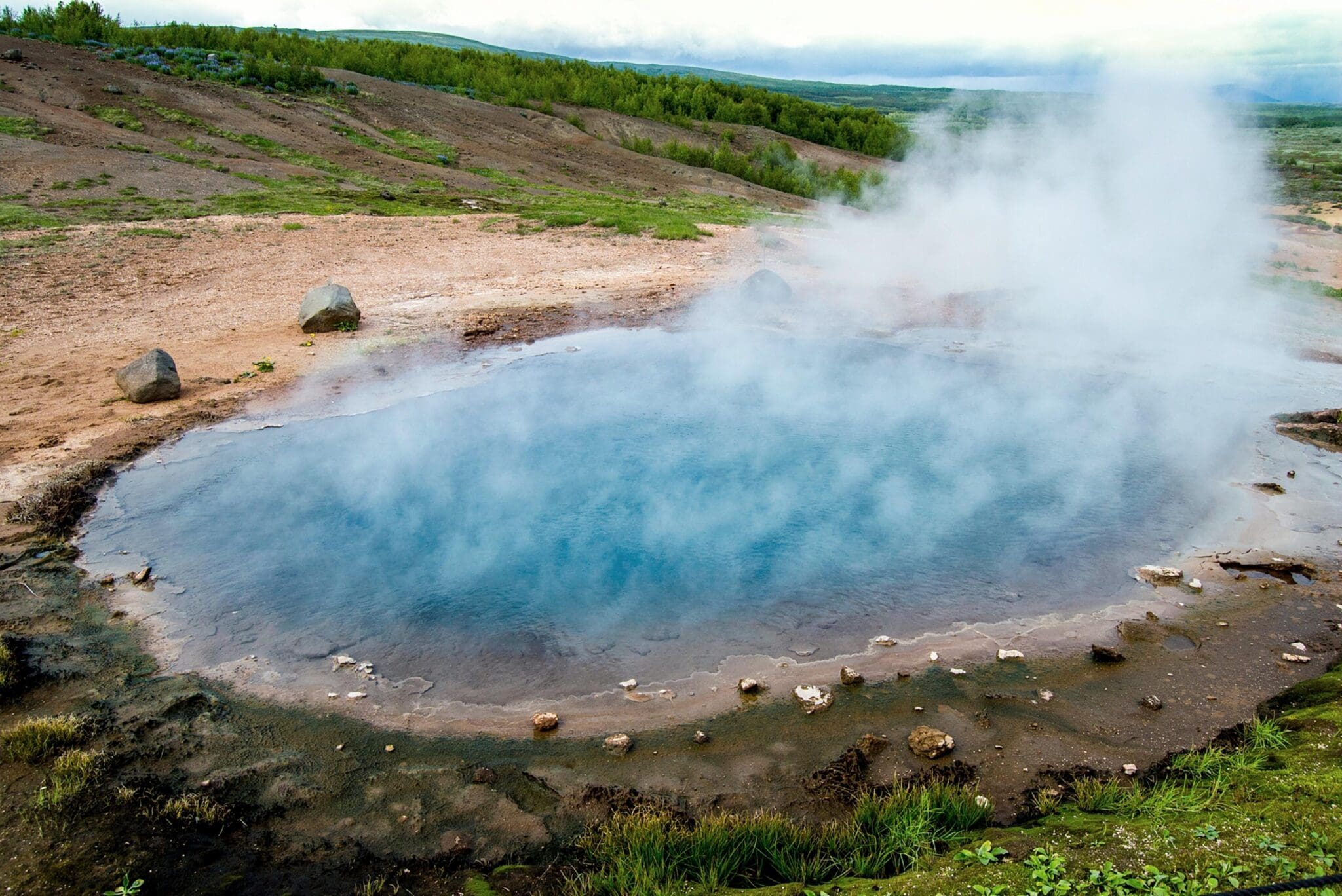
Le Geysir hot springs geothermal area, situated in Haukadalur (e. Hawks’ Valley), is a high-temperature area with colorful hot springs and mud pools. Its main attraction is Strokkur (e. Churner), the only currently spouting hot spring in this area, which makes this the only place in Europe with a spouting hot spring. Every 5-8 minutes, Strokkur spouts scalding geothermal water up to 30 meters into the air, so try staying upwind of it to avoid the hot water and steam blowing over you when it spouts.
Geysir (e. Spouter) is the most renowned geological phenomenon in Iceland, giving its collective name geyser to all other hot springs in the world. It is currently dormant and hasn’t spouted since 2016, but earthquakes in the area and volcanic activity in our country may cause Geysir to awaken someday and the other hot springs in this geothermal area to show changes in behavior.
Other hot springs in this area to mention are Blesi (e. Blaze), a blue hot spring due to dissolved silica coming in contact with the atmosphere, and Konungshver (e. The King’s Hot Spring), the largest and the most attractive hot spring in the area. Konungshver’s name commemorated the 1874 visit of King Christian IX when Icelanders were still under the reign of the Kingdom of Denmark.
A short and easy hike up to an observation platform on Laugarfell (e. Hot Spring Hill) gives you a view over the whole geothermal area of these hot springs.
Gullfoss (e. Golden Falls), is a magnificent waterfall, believed to have gotten its name from the golden hue shining in its glacial water. Located in a narrow gorge of basalt lava columns, Gullfoss is located in the third-longest river in Iceland, Hvita (e. White River), a white glacial river flowing from its source Hvítárvatn (e. White River Lake), fed by glacial water from the second-largest glacier in Iceland, Langjökull (e. Long Glacier). Gullfoss consists of two cascades, forming a tiered three-step “staircase”, with white glacial water plunging 32m down into the 2.5km wide basalt gorge Gullfossgljúfur (e. Golden Falls Gorge).
Next to Gullfoss is a walking trail to go up to the 21-meter lower cascade and the 11-meter upper cascade. On sunny days, a rainbow forms from spraying water by Gullfoss, and sometimes even spectacular double rainbows. Sigríður Tómasdóttir (b. 1871) was a daughter of the farmer Tómas Tómasson, who lived at the farm Brattholt. Gullfoss belonged to her father’s land, but at the beginning of the 20th century, Tómas was tricked into renting Gullfoss to foreign investors who planned to harness its power by building a hydroelectric powerplant to generate electricity. Sigríður loved Gullfoss more than anything else, and so she took the investors to court to annul their contract and protested their plans of harnessing Gullfoss by threatening to throw herself down this waterfall if it would come to be exploited and destroyed. To draw attention to her protests, Sigríður went barefoot on a 120 km protest march from Gullfoss to Reykjavik. After her march on unpaved mountain roads, Sigríður was bleeding from her soles and in a very bad shape. She lived to be 86 when she died in 1957, living all her life on the Brattholt farm, and is widely seen as Iceland’s first environmentalist and activist, and one of the first guides for those visiting Gullfoss. Thanks to Sigríður, Gullfoss was saved and today Gullfoss is owned by the state of Iceland for preservation, becoming a permanent nature reserve in 1979. Gullfoss is among the most visited attractions in Iceland, giving its name to the Golden Circle. A memorial sculpture in honor of Sigríður is situated by the walking path leading up to Gullfoss.
La cascade majestueuse de 62 m (203 pi) de haut Seljalandsfoss est alimenté par l'eau de source provenant de la lande Hamragarðaheiði et fait partie de la rivière Seljalandsá. Beaucoup pensent qu'il est alimenté par l'eau fondante provenant du glacier coiffé Eyjafjallajökull, (en), un volcan qui est entré en éruption en 2010 et a affecté le trafic aérien partout Europe, [traduction], mais l'eau de Seljalandsfoss est lumineuse et propre du fait qu'il s'agit d'eau de source Elle tombe en cascade dans une belle prairie, comme un rideau sur une haute falaise qui marquait autrefois un littoral par l'océan avant que les éruptions n'étendent la terre, et derrière la cascade se trouve un sentier pédestre pour un angle unique de la cascade et de ses environs Ce sentier continue de derrière la cascade et autour de celle-ci La pittoresque Seljalandsfoss est parmi les cascades les plus photographiées d'Islande pour une raison Par exemple, elle a été présentée dans Justin Bieber‘s clip vidéo Je vais te montrer et c'était la première étape de la sixième saison de la série américaine La course incroyable.
Assurez-vous de porter des chaussures avec une bonne adhérence si vous prévoyez de marcher derrière Seljalandsfoss car il peut être glissant, et portez des vêtements imperméables en raison de la pulvérisation de la cascade.
We’ll also make a short walk to Seljalandsfoss’ neighbor Gljufrabúi, a 40 m (131 ft) high partially hidden waterfall in the river Gljúfursá within a canyon with mossy walls, which is a great addition to the spectacular visits on the south coast of Iceland. You will however need waterproof shoes to get to Gljúfrabúi.
Skógafoss est l'une des plus belles cascades d'Islande tombant à 60 m (197 ft) d'une falaise érodée avec une largeur étonnante de 25 m (82 ft) et jusqu'à 30 m (98 ft) après de fortes pluies Elle est située sur la rivière Skógá qui coule de dessous Eyjafjallajökull, [TRADUCTION] ?Un volcan coiffé d'un glacier qui a éclaté pour la dernière fois en 2010. lors de cette éruption, Skógafoss est devenu gris à cause de toutes les cendres qui soufflaient dans la rivière Skógá Skógafoss produit une grande quantité de pulvérisation donc les jours ensoleillés, vous pouvez voir un arc-en-ciel se former, certains jours même un double arc-en-ciel Sous la cascade, la terre est plate, ce qui rend facile de marcher jusqu'à elle, mais notez que vous pouvez être mouillé à cause de la pulvérisation Si vous êtes prêt pour cela, vous pouvez également voir Skógafoss depuis le sommet puisqu'un escalier à marches de 527 mène à une plate-forme d'observation au-dessus avec une vue imprenue sur la côte populaire avec une vue sur la côte de Skaf et des vidéos de la côte populaire. Fjara par Solstafir en 2012 et Je vais te montrer par Justin Bieber en 2015, les films de 2013 Thor : Le monde sombre et La vie secrète de Walter Mitty, « , et la série télévisée » Vikings (saison 5) et Jeu de trônes (saison 8).
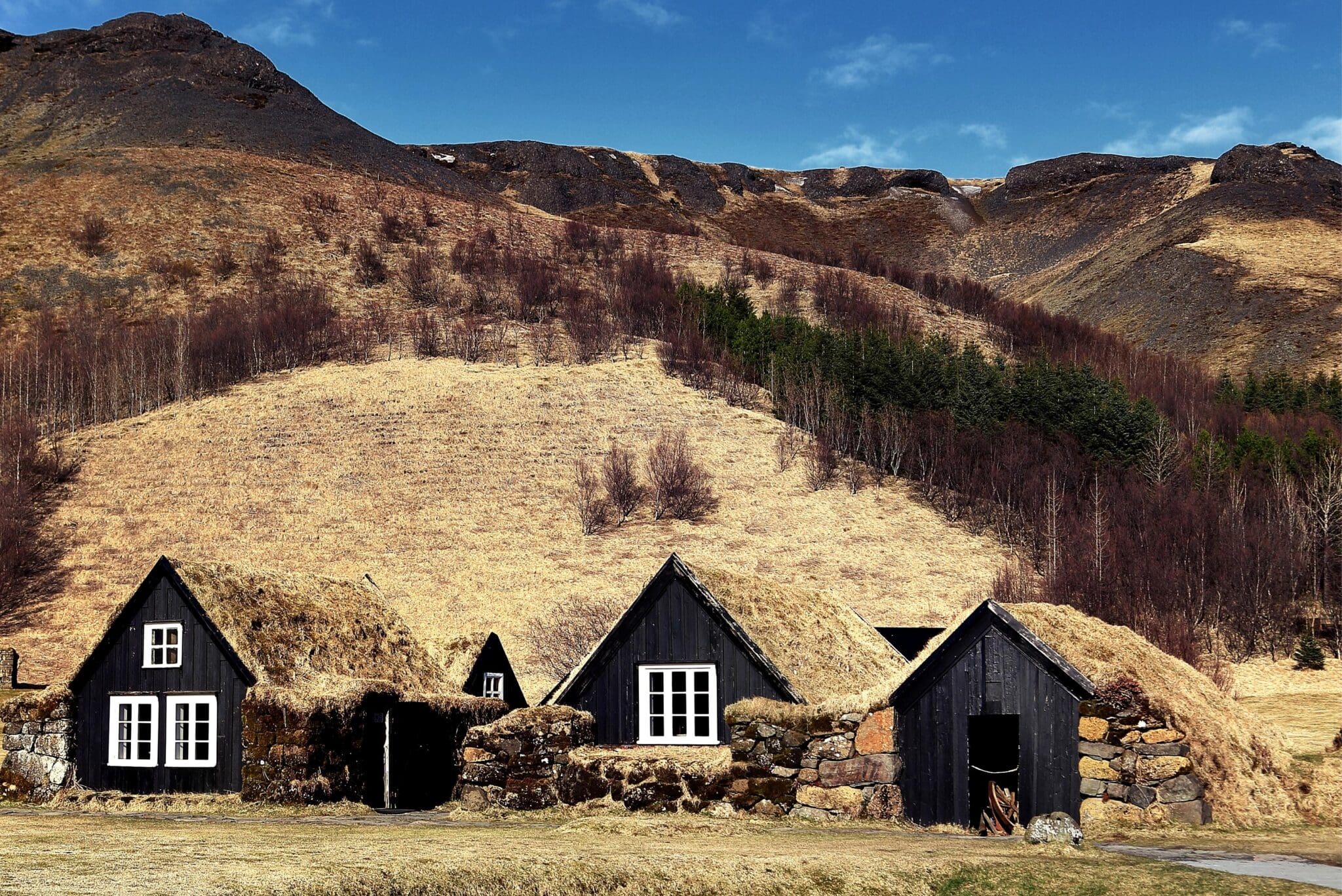
Skógafoss se trouve dans le petit village de Skógar avec une population d'environ 25 personnes, et le Musée régional de Skógar est proche de la cascade, avec plus de 18 000 artefacts régionaux dans six bâtiments historiques C'est trois musées dans un qui montrent comment les Islandais ont vécu tout au long de l'histoire ; un musée en plein air avec de vieilles maisons en bois et des maisons en gazon, un musée folklorique avec une collection du patrimoine culturel, et un musée technique montrant l'évolution des transports, de la communication, et de la technologie en Islande Dans le musée folklorique est un manche doré remarquable qui est dit être d'un coffre rempli d'or, appartenant au colon ̄rasi uférolfsson qui a caché la poitrine derrière Skógafoss avant sa mort vers 900 après JC. Beaucoup ont tenté de la récupérer jusqu'au jour où une corde a été fixée à la poignée pour retirer la poitrine, mais la poignée s'est cassée, laissant la poitrine remplie d'or perdue à jamais. Cette poignée servait de poignée de porte sur le Skógakirkja église jusqu'en 1890.
Resting in the gorge Kvernugil close to Skógafoss is the 30 m (98 ft) high waterfall Kvernufoss which is considered a hidden gem. It is like a counterpart mix of the waterfalls Seljalandsfoss et Gljufrabúi, being inside a mossy walled canyon with a cave behind it that provides walking behind it.
La belle Reynisfjara la plage de sable noir est l'une des visites les plus populaires du sud de l'Islande. La plage poncée inhabituellement noire avec des vagues océaniques agitées frappant le mur aux colonnes de basalte constitue une attraction spectaculaire et en 2021, elle a été classée par Grand 7 Voyage en tant que 6ème meilleure plage à visiter sur leur liste annuelle de Les 50 meilleures plages du monde, [TRADUCTION], mettre en valeur les plages incontournables Reynisfjara peut être très dangereux avec ses puissantes vagues océaniques et ses chutes de pierres provenant des falaises en raison de l'érosion côtière Les deux peuvent souvent être très inattendues et tragiquement mortelles des accidents s'y sont produits au fil des ans Il peut être tentant de se faire prendre en photo après avoir grimpé sur les colonnes de basalte, mais les gens ont été surpris par un subitement “neaker wave” les arrachant et le ressac les forces qui les tirent vers la mer. Rien ne peut être fait si cela se produit donc il n'y a pas de retour en arrière après cela Les vagues peuvent paraître calmes, mais près du rivage l'océan est extrêmement prudent.
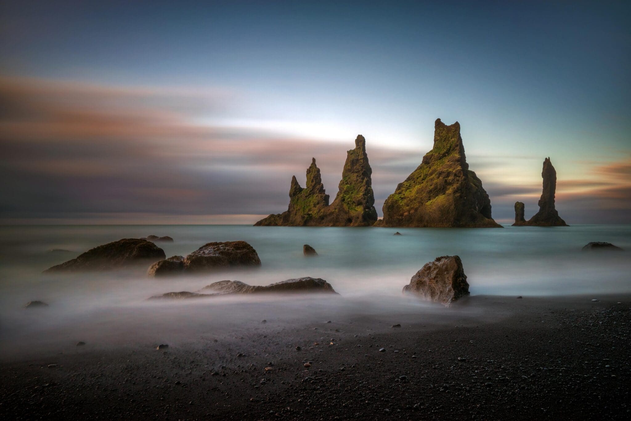
Reynisdrangar est une collection de pinacles de mer basaltiques de 66 m (216 pi) de haut s'élevant hors de la mer par Reynisfjara Un vieux conte dit qu'ils proviennent du moment où deux trolls ont essayé de traîner un trois-mâts pour atterrir la nuit, mais quand la lumière du jour s'est brisée ils sont devenus avec le navire ces piles de pinacles qui se détachent dans la mer Reynisdrangar est la même formation géologique que la haute montagne de 340 m (1 115 pi) Reynisfjall planant au-dessus d'eux Cette montagne est faite de tuf volcanique d'une éruption sous un glacier à l'avant-dernière période glaciaire, avec des couches irrégulières de tuf, de lave en oreiller, et des veines et boucles de basalte en colonnes Les flancs des montagnes sont escarpés et près de la plage, on peut voir ces belles formations de colonnes de basalte C'est le site de nidification des macareux et autres oiseaux marins, alors s'il vous plaît ne pas essayer de grimper jusqu'à eux pour ne pas les déranger Les colonnes de basalte sont une grande inspiration pour Hallgrimskirkja église, ouséjóðleikhúsið (e. Le Théâtre national d'Islande), et Salle de concert et centre de conférence Harpa. Dans la partie sud de Reynisfjara, près de la plage, se trouve Hálsanefshellir, [TRADUCTION], une grotte de basalte extrêmement belle, S'il vous plaît, n'essayez d'y entrer que lorsqu'il y a une marée basse pour que les vagues ne vous en sortent pas, et sachez que des rochers peuvent soudainement tomber.
Vous reconnaîtrez peut-être cette zone à l'islandais Netflix série Katla, la 7 e saison de la série Jeu de trônes, le film de 2013 Star Trek : Dans les ténèbres, & le film de 2014 Noé.
27.999 ISK
23.002 ISK
129.990 ISK
183.824 ISK
174.554 ISK

231 000 ISK
179.350 ISK
152.900 ISK
137 500 ISK
170 500 ISK