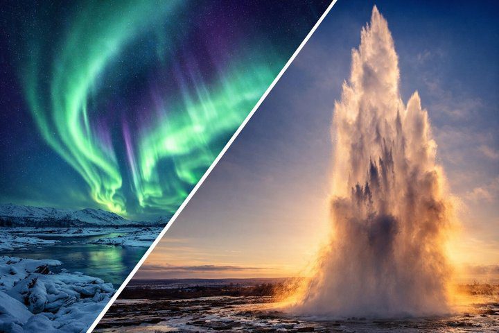
Golden Circle with 6 stops and Northern Lights Private Tour
200.195 ISK
8 horas y 30 minutos

Fácil
280.000 ISK
Tenga en cuenta:
El clima puede ser impredecible en Islandia, por lo que durante el invierno es posible que necesitemos modificar ocasionalmente el itinerario del recorrido si las condiciones climáticas o de la carretera son desfavorables.
Disponible: Todo el año
Duración: Approx. 10hrs, depending on time spent at stops.
Recogida: Desde su hotel/alojamiento dentro del área de la capital de Reykjavik.
Aspectos destacados
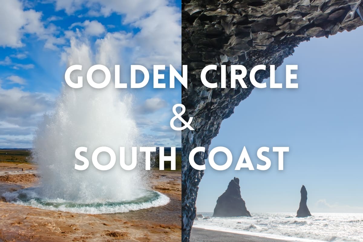
The Golden Circle:
The South Coast:
Descripción
If you have limited time in Iceland, you can combine the most popular attractions during your stay: the classical Círculo Dorado y Costa Sur!
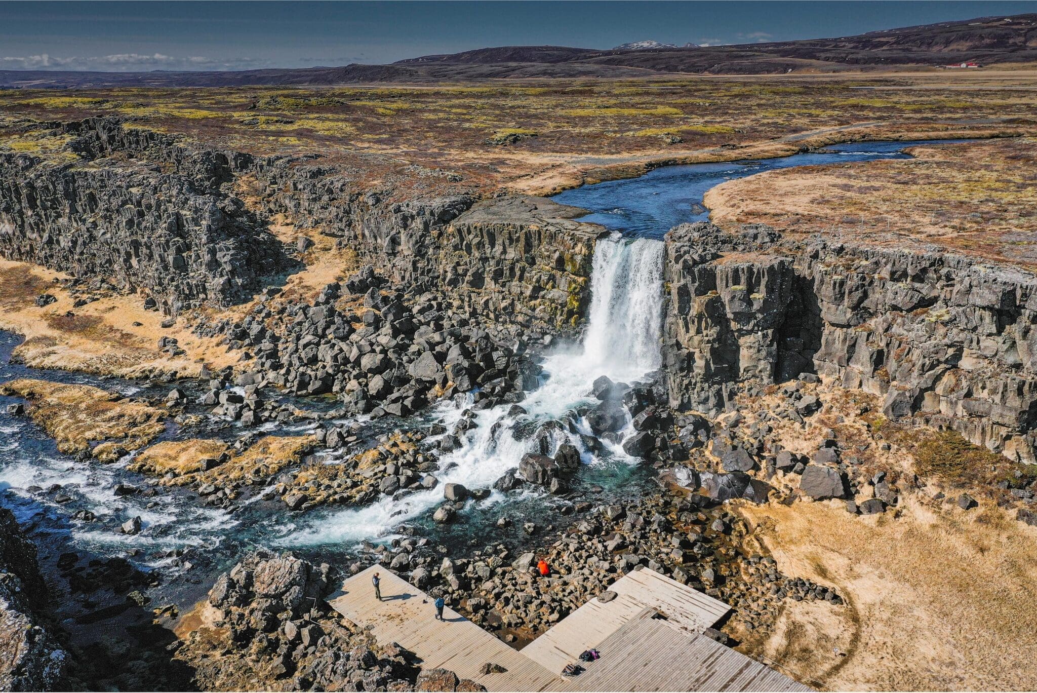
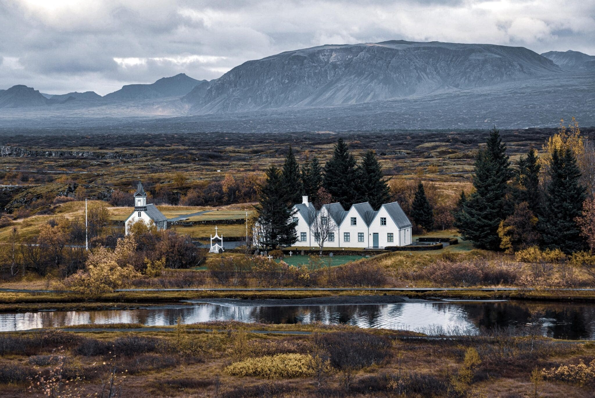
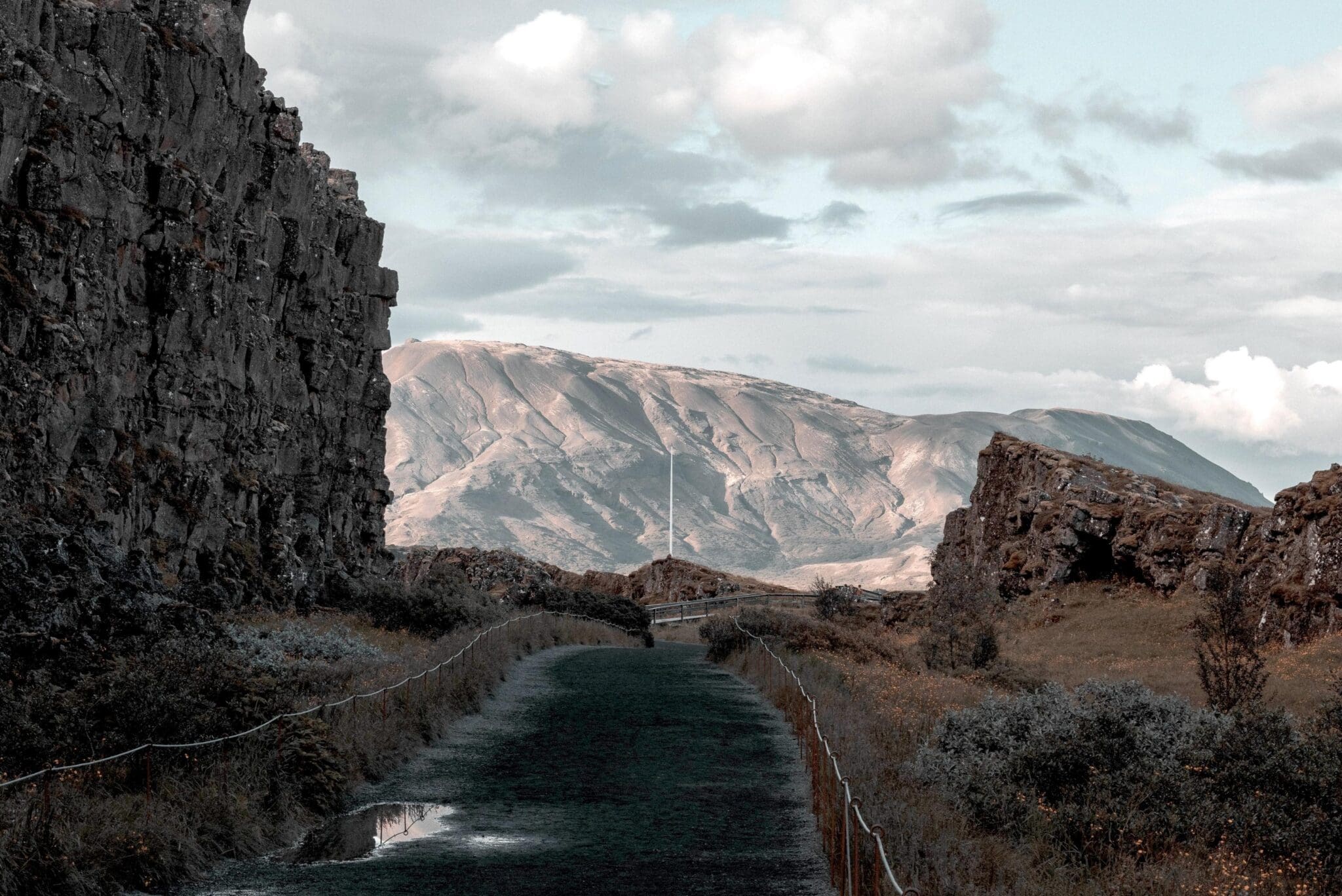
Heading out of the city, you will pass Icelandic farms on the way to the first stop of the tour; Thingvellir Parque Nacional. This is the first national park in Iceland and the first Patrimonio de la Humanidad por la UNESCO in our country. You will start at Hakið lava mesa, a viewpoint that gives you an amazing view over the Thingvellir area and Cosavallavatn, the largest natural lake in Iceland (about 83.7 square kilometers and 114 meters at its deepest point). You go down from Hakið into Almannagjá by Thingvallabær rectory, today serving as the Prime Minister's summer house, and Cosavallakirkja, a beautiful wooden church representative for common Icelandic churches. In Almannagjá dwells Öxarárfoss, a 12-meter man-made waterfall from when the Vikings changed the course of the Öxará river to channel into Almannagjá, so they could water their horses and sheep when assembling at Althingi each summer, the Icelandic parliament.
Thingvellir may look familiar to you if you're a Juego de Tronos fan, since episodes 1, 5, and 8 of season four were shot here.
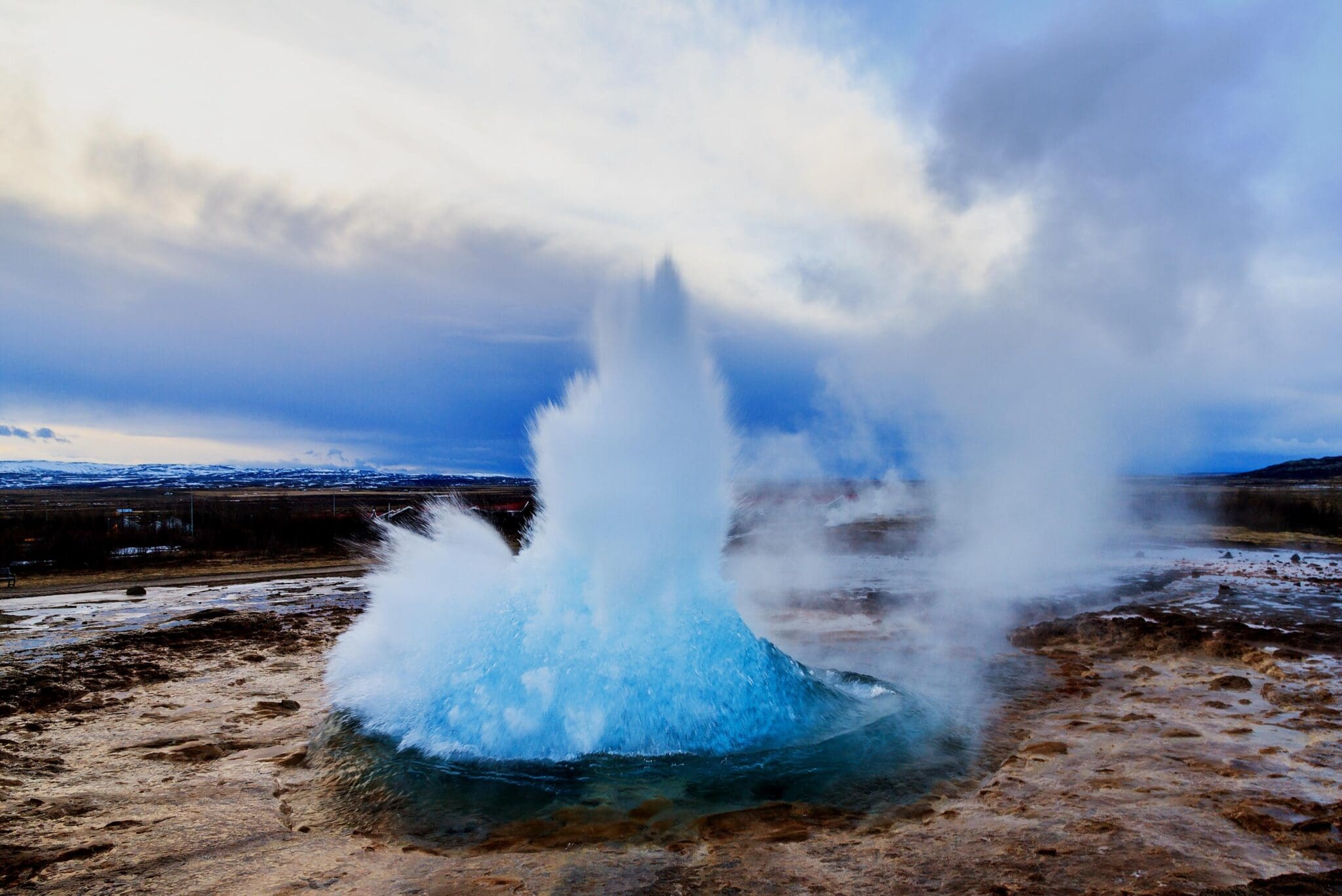
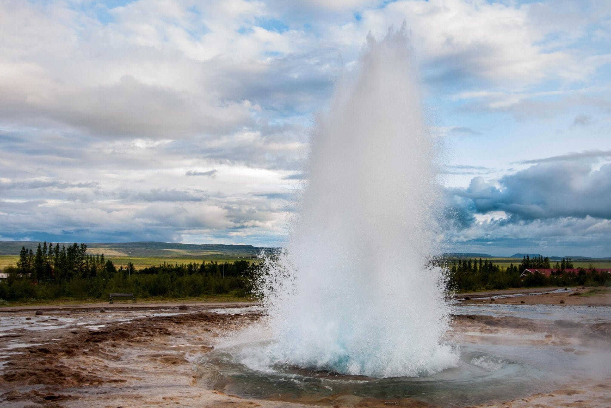
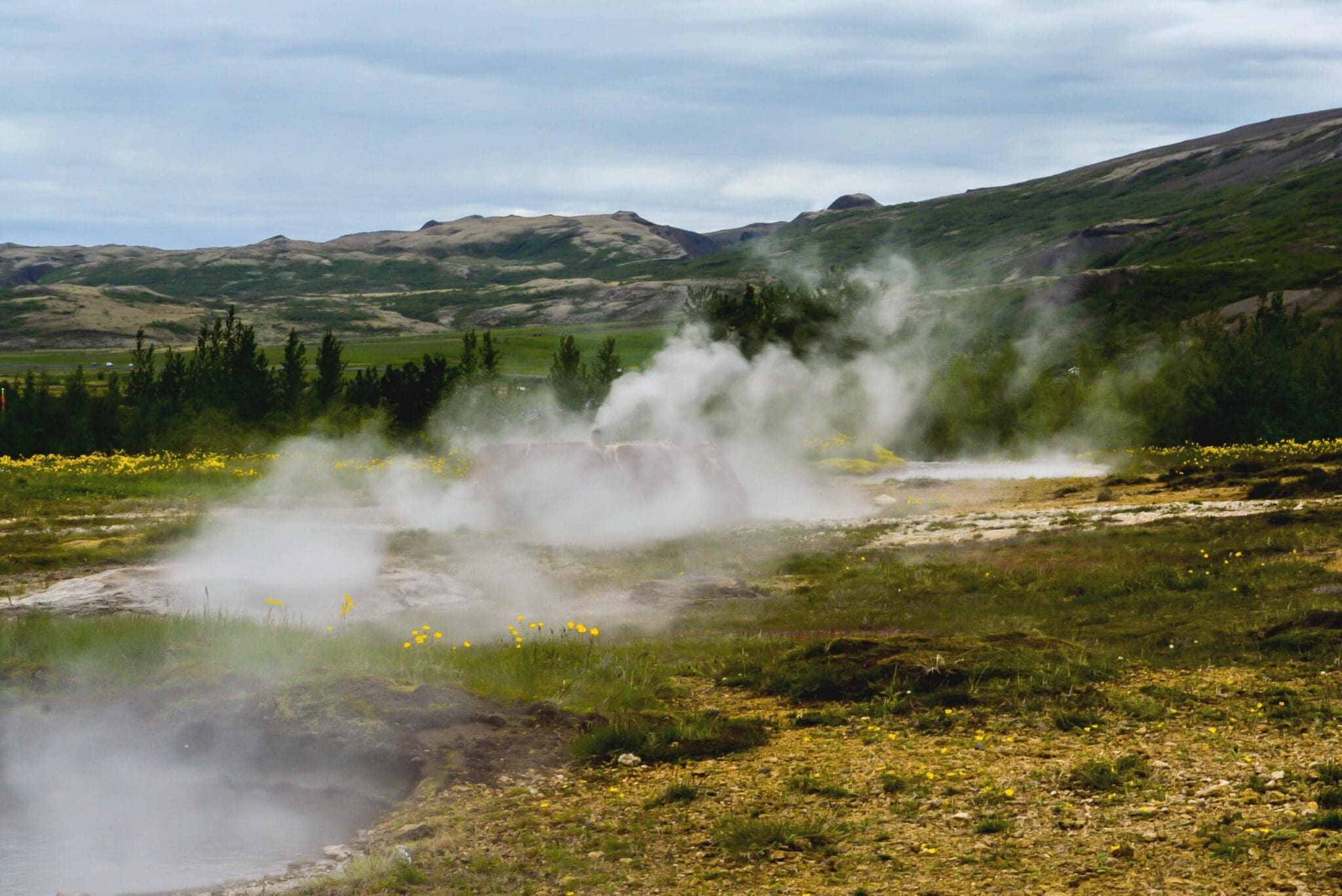
Driving through the wooden Thingvellir National Park, passing more beautiful farmsteads, the next stop is the Geysir zona geotérmica de aguas termales en Haukadalur valley. This high-temperature area with its colorful hot springs and mud pools is the only place in Europe with hot springs that spout. Geysir is Iceland's most well-known geological phenomenon, giving its collective name géiser to all other hot springs in the world. It is dormant and hasn't spouted since 2016, but its neighbor Strokkur still does every 5-8 minutes, shooting 30 meters of scalding geothermal water into the air. Earthquakes in the area and volcanic activity in our country may cause Geysir to awaken and other hot springs in this geothermal area to show changes.
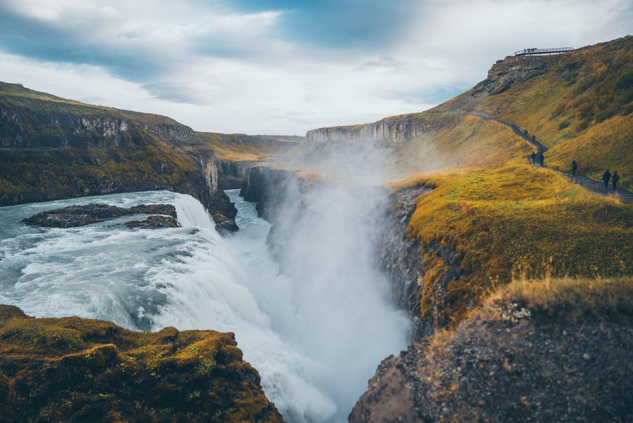
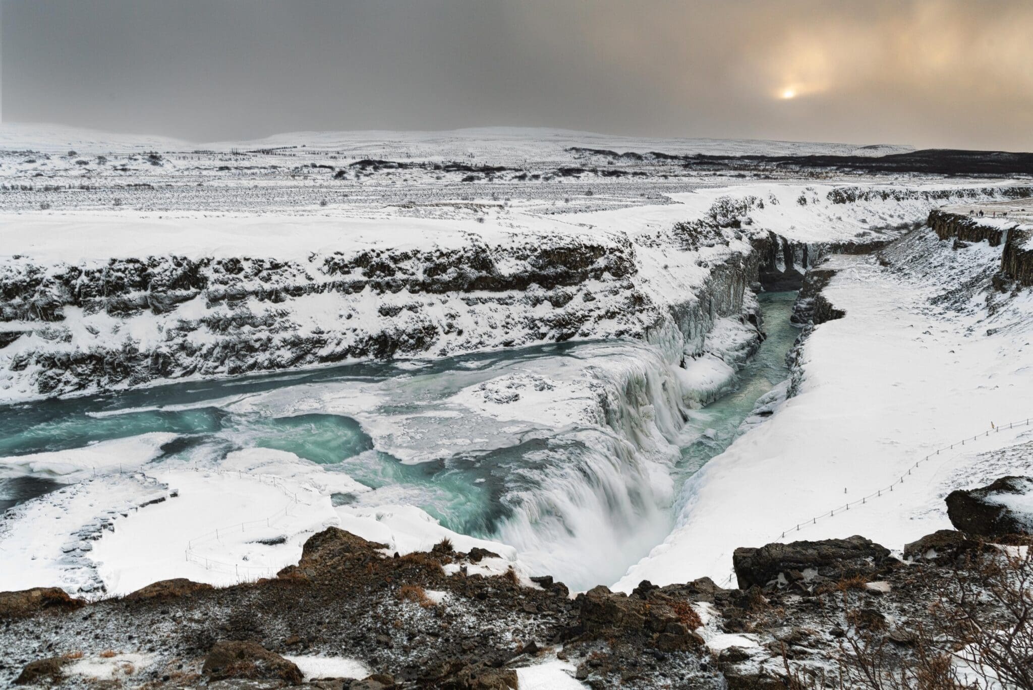
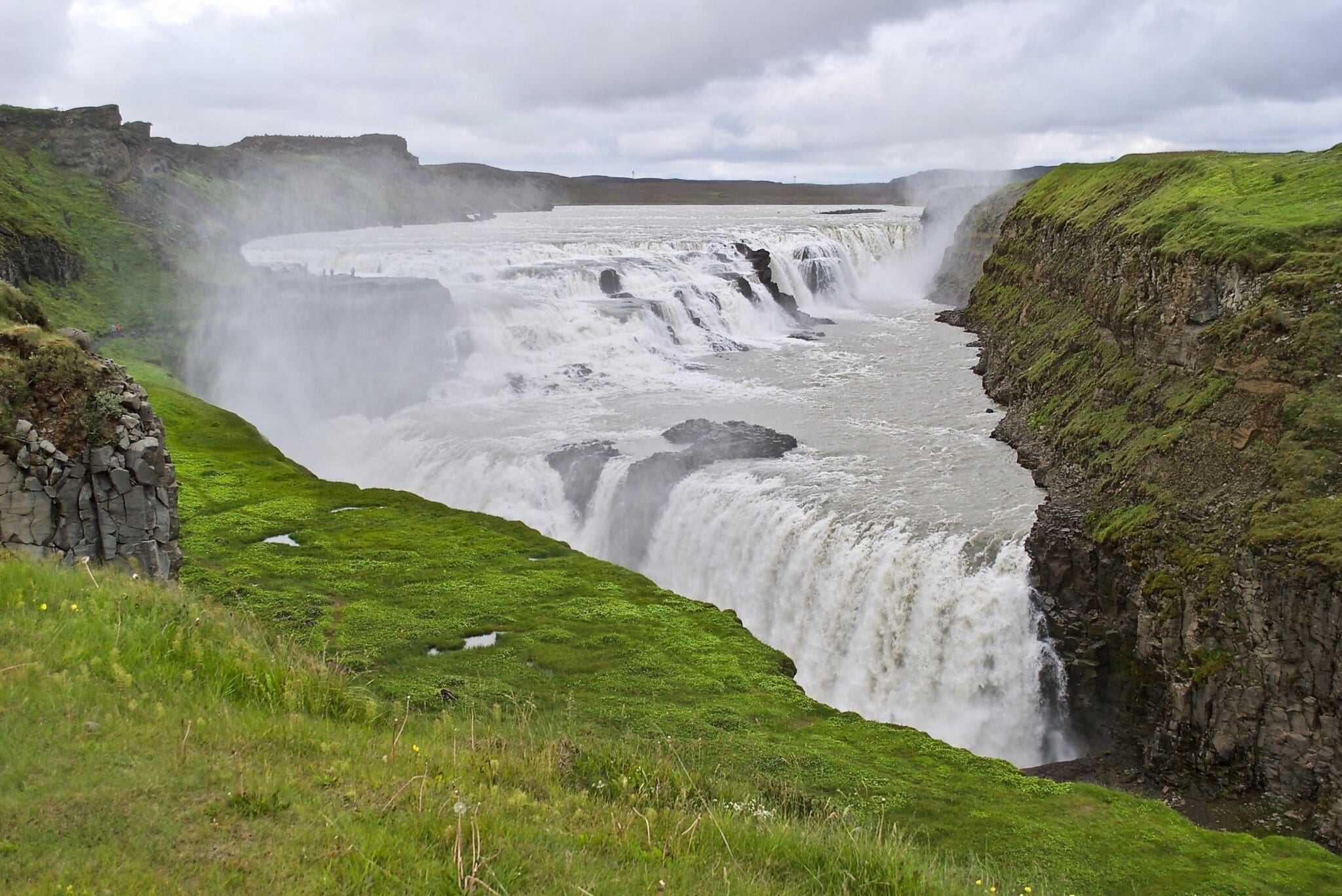
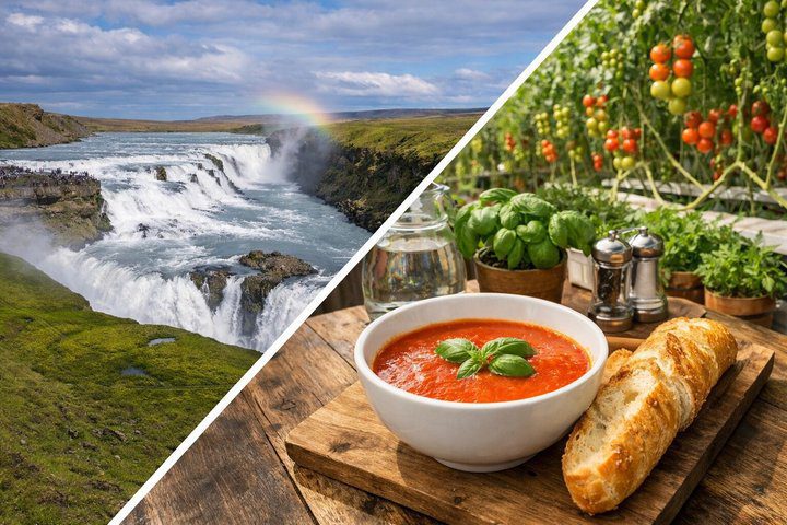
The last stop is what the Golden Circle derives its name from; Gullfoss waterfall, meaning Cataratas Doradas. This magnificent tiered three-step waterfall is considered the queen of all waterfalls in Iceland, plunging 32 meters into a narrow basaltic gorge. The white glacial river Hvíta, alimentado por el Langjökull glacier, gives Gullfoss its white and blueish color, and on sunny days its spraying mist forms a spectacular rainbow, sometimes even a double rainbow.
Driving further south we get closer to the coastline with the Atlantic Ocean on one side and volcanoes and glaciers on the other side, and even the famous Hekla volcano can be seen from the road.
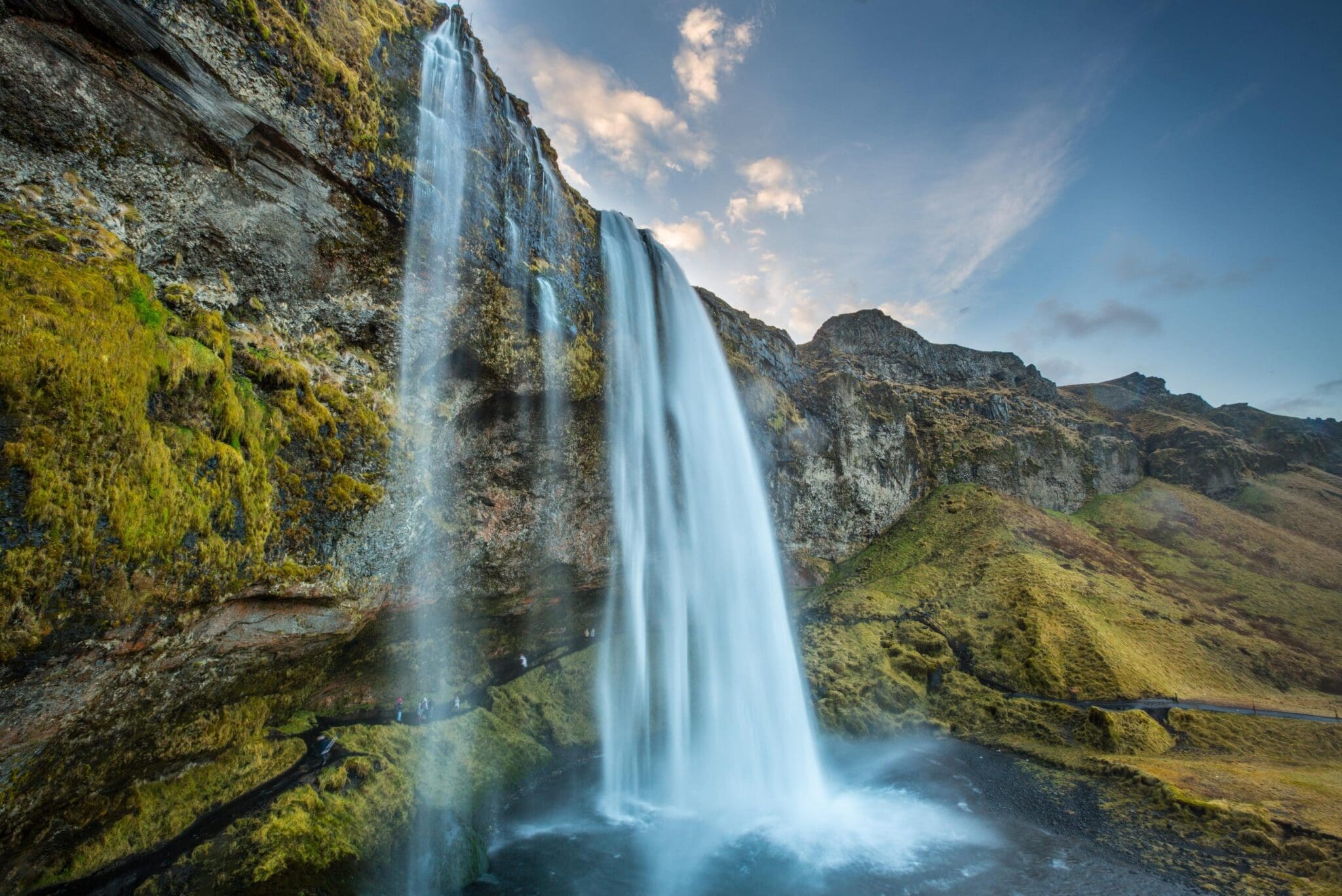
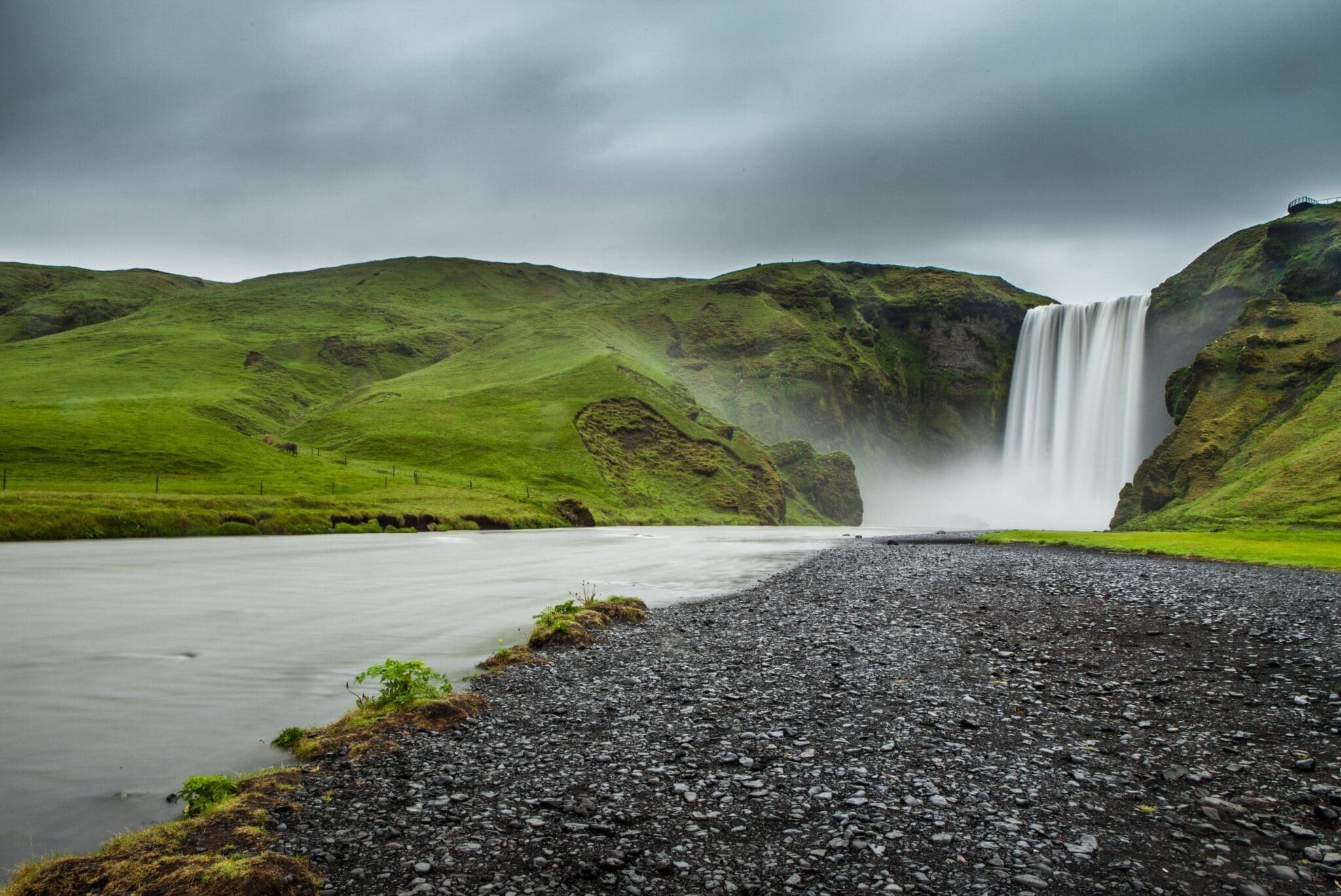
We make our first stop on the South Coast at the unique waterfall Seljalandsfoss, which drops like a curtain off a cliff into a beautiful meadow. Behind is a small cave and a walking path extending around the waterfall. This makes for a great angle to photograph this very picturesque waterfall and its surroundings, but be sure to wear good shoes and waterproof clothing before going behind it. We head on and drive past the ice cap Eyjafjallajökull which covers the caldera of a volcano that last erupted in 2010, memorably affecting air traffic throughout Europe. From the road, you will immediately spot the mesmerizing Skógafoss in the tiny Skógar village. It is one of the most beautiful waterfalls in Iceland dropping wide from a cliff that formerly marked the coastline. If the sun is out, the spraying from Skógafoss will form a rainbow and sometimes two. A staircase next to it leads up to a platform above this waterfall, giving you a great view over farmsteads to the ocean and on-site museums give you insight into how Icelanders lived throughout history.
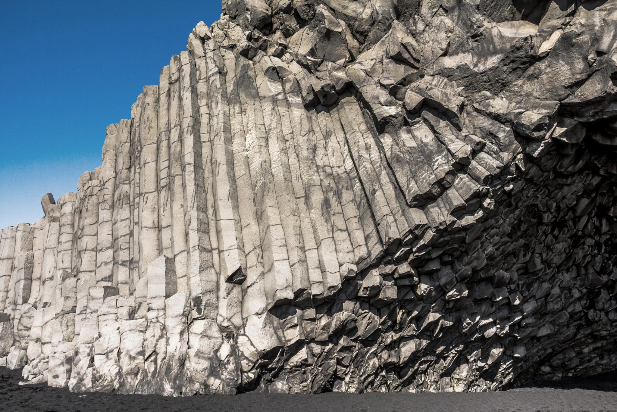
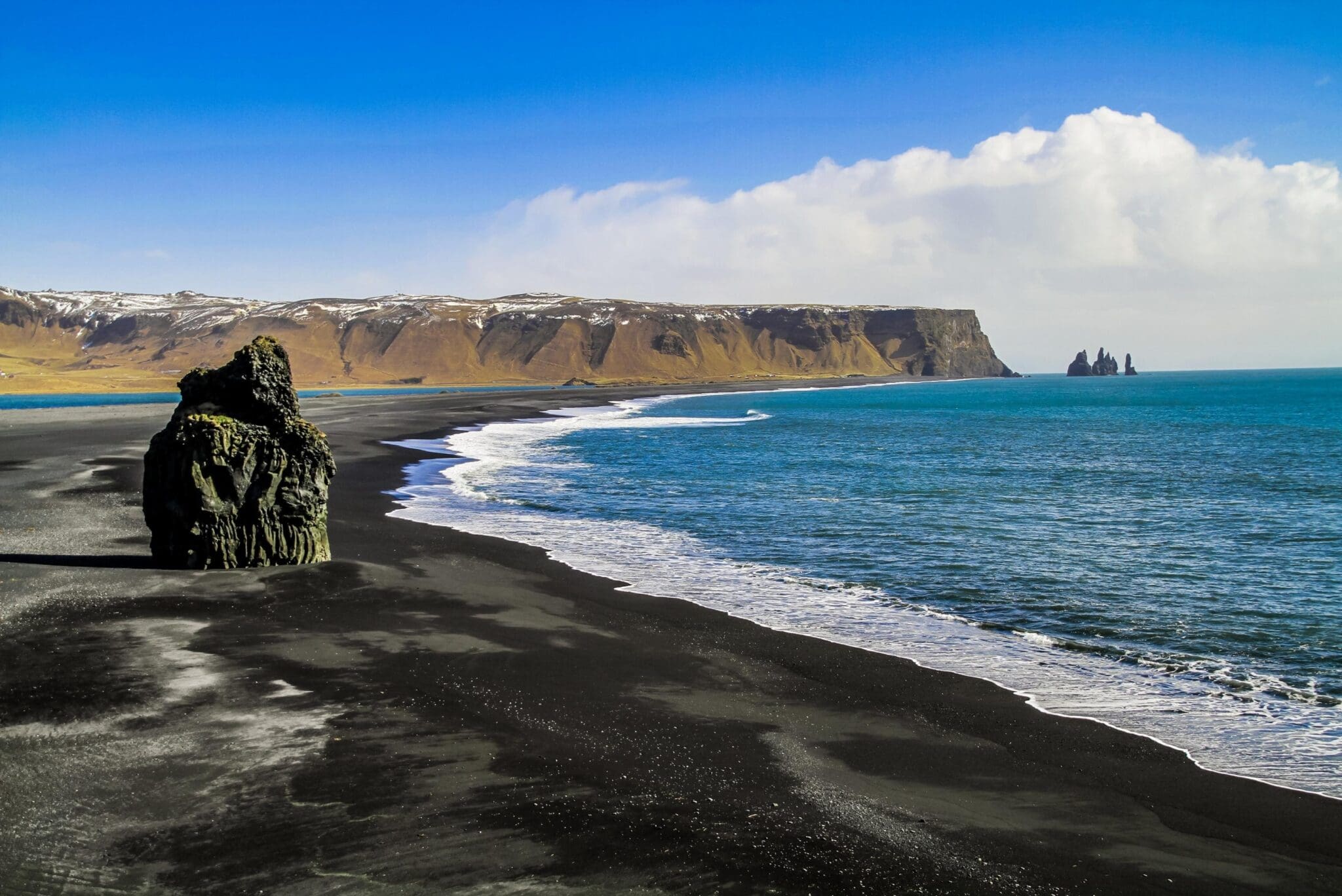
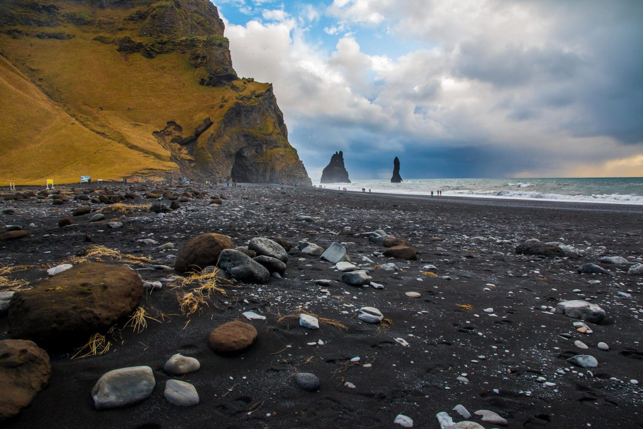
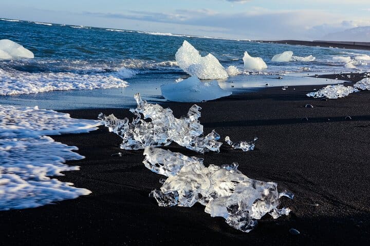
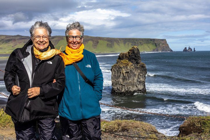
Our last stop is Reynisfjara black sand beach, the most popular visit on the South Coast, with the high basalt pinnacles Reynisdrangar rising out of the sea, and extremely powerful ocean waves crashing against the basalt-columned wall of mountain Reynisfjall and steadily eroding the Hálsanefhellir basalt cave by the beach. Here you need to be extra cautious, as these waves are known as "sneaker waves". Though they may sometimes look calm and harmless, they have snuck up on people and pulled them into the sea, causing fatal tragedies throughout the years when people have gotten too close to the sea. Be careful while admiring this breathtaking area and please respect the puffins and other seabirds nesting in the basalt columns.
After this long day of exceptional landscapes and scenery, we make our way back to the buzzing city life of the Reykjavik Capital Area.
El Parque Nacional Thingvellir se creó en 1930 y fue el primer parque nacional de Islandia. Luego, en 2004, se convirtió en el primero Patrimonio de la Humanidad por la UNESCO en Islandia por su patrimonio cultural de la época vikinga y la importancia de su historia y naturaleza.
«ingvellir (e. Terrenos del Parlamento) es una zona de fractura situada sobre las placas tectónicas del Cordillera del Atlántico Medio, el Continentes norteamericano y euroasiático, que atraviesa Islandia desde su esquina NE hasta la esquina SO, formando una gran depresión de unos 40 km de largo y 10 km de ancho. Estos límites sólo son visibles sobre el suelo en muy pocos lugares de Islandia. Almannagjá (e. La ruptura del público) forma los límites orientales de la placa norteamericana, mientras Hrafnagjá (e. Grieta del cuervo) forma los límites occidentales de la placa euroasiática. El área entre estas dos fisuras está disminuyendo lentamente, separándose entre 3 y 4 milímetros cada año.
Al« (e. Asamblea General) es el parlamento islandés, establecido en el año 930 d.C. por los vikingos, y es el parlamento más antiguo del mundo. Cada verano, los islandeses se reunían allí hasta 1798 para establecer leyes, resolver disputas, comerciar bienes y llevar a cabo castigos y ejecuciones. Fue en Althingi donde la nación islandesa acordó adoptar el cristianismo en el año 1000 d. C., reemplazando a la religión pagana Asatru. El 17 de junio de 1944, se declaró en vigor el establecimiento de la República de Islandia después de siglos de estar bajo los reinados de los Reinos de Noruega y Dinamarca.
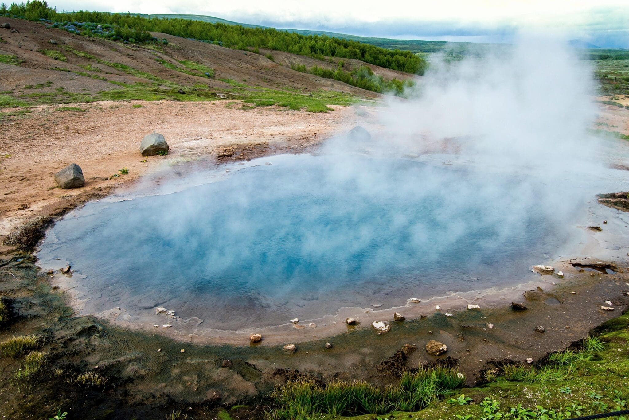
El Geysir zona geotérmica de aguas termales, situado en Haukadalur (e. Valle de los Halcones), es una zona de alta temperatura con coloridas aguas termales y piscinas de barro. Su principal atractivo es Strokkur (e. Churner), la única fuente termal que actualmente brota en esta zona, lo que la convierte en el único lugar de Europa con una fuente termal. Cada 5-8 minutos, Strokkur arroja agua geotérmica hirviendo hasta 30 metros en el aire, así que intenta permanecer contra el viento para evitar que el agua caliente y el vapor soplen sobre ti cuando brota.
Geysir (e. Spouter) es el fenómeno geológico más reconocido en Islandia, dando su nombre colectivo géiser a todas las demás aguas termales del mundo. Actualmente está inactivo y no ha brotado desde 2016, pero los terremotos en la zona y la actividad volcánica en nuestro país pueden provocar que Geysir despierte algún día y que las demás aguas termales de esta zona geotérmica muestren cambios de comportamiento.
Otras aguas termales en esta zona a mencionar son Blesi (e. Ardor), una fuente termal azul debido a la entrada de sílice disuelta en contacto con la atmósfera, y Konungshver (e. Las aguas termales del rey), la fuente termal más grande y atractiva de la zona. El nombre de Konungshver conmemoró la visita del rey Cristián IX en 1874, cuando los islandeses todavía estaban bajo el reinado del Reino de Dinamarca.
Una caminata corta y fácil hasta una plataforma de observación Laugarfell (e. Colina de aguas termales) le ofrece una vista de toda la zona geotérmica de estas aguas termales.
Gullfoss (e. Cataratas Doradas), es una magnífica cascada, que se cree que debe su nombre al tono dorado que brilla en sus aguas glaciales. Situado en un estrecho desfiladero de columnas de lava basáltica, Gullfoss se encuentra en el tercer río más largo de Islandia, Hvíta (e. Río Blanco), un río glacial blanco que fluye desde su nacimiento Hvítarvatn (e. Lago del río Blanco), alimentado por agua glacial del segundo glaciar más grande de Islandia, Langjökull (e. Glaciar Largo). Gullfoss consta de dos cascadas, que forman una “escalera” escalonada de tres escalones, con agua glacial blanca que se hunde 32 m en el desfiladero de basalto de 2,5 km de ancho Gullfossgljúfur (e. Garganta de las Cataratas Doradas).
Junto a Gullfoss hay un sendero para caminar que sube a la cascada inferior de 21 metros y a la cascada superior de 11 metros. En los días soleados, se forma un arco iris a partir de la rociación de agua por parte de Gullfoss y, a veces, incluso espectaculares arcos iris dobles. Sigriður Tomasdóttir (n. 1871) era hija del granjero Tomas Tomasson, que vivía en la finca Brattholt. Gullfoss pertenecía a la tierra de su padre, pero a principios del siglo XX, Tomas fue engañada para que alquilara Gullfoss a inversores extranjeros que planeaban aprovechar su energía construyendo una central hidroeléctrica para generar electricidad. Sigríður amaba a Gullfoss más que cualquier otra cosa, por lo que llevó a los inversores a los tribunales para anular su contrato y protestó por sus planes de aprovechar Gullfoss amenazando con arrojarse a esta cascada si llegaba a ser explotada y destruida. Para llamar la atención sobre sus protestas, Sigríður se puso descalza en una marcha de protesta de 120 kilómetros desde Gullfoss hasta Reykjavik. Después de su marcha por caminos de montaña sin pavimentar, Sigriður sangraba por las plantas de sus pies y estaba en muy mal estado. Vivió hasta los 86 años cuando murió en 1957, vivió toda su vida en la granja Brattholt y es ampliamente vista como la primera ambientalista y activista de Islandia, y una de las primeras guías para quienes visitan Gullfoss. Gracias a Sigriður, Gullfoss se salvó y hoy Gullfoss es propiedad del estado de Islandia para su conservación, convirtiéndose en una reserva natural permanente en 1979. Gullfoss se encuentra entre las atracciones más visitadas de Islandia, dando nombre al Círculo Dorado. Una escultura conmemorativa en honor a Sigriður está situada junto al sendero que conduce a Gullfoss.
The 62 m (203 ft) high majestic waterfall Seljalandsfoss is fed by spring water originating in the moor Hamragarðaheiði and is part of the river Seljalandsá. Many think it is fed with melting water from the glacier-capped Eyjafjallajökull, a volcano that famously erupted in 2010 and affected air traffic throughout Europe, but the water in Seljalandsfoss is bright and clean due to it being spring water. It cascades into a beautiful meadow, like a curtain over a tall cliff that once marked a coastline by the ocean before eruptions extended the land, and behind the waterfall is a walking path for a unique angle of the waterfall and its surroundings. This trail continues from behind the waterfall and around it. The picturesque Seljalandsfoss is among the most photographed waterfalls in Iceland for a reason. For instance, it was featured in Justin Bieber‘s music video I’ll Show You and was the first leg of the sixth season of the American series The Amazing Race.
Be sure to wear shoes with a good grip if you plan on walking behind Seljalandsfoss as it can be slippery, and wear waterproof clothing due to the spraying from the waterfall.
We’ll also make a short walk to Seljalandsfoss’ neighbor Gljúfrabúi, a 40 m (131 ft) high partially hidden waterfall in the river Gljúfursá within a canyon with mossy walls, which is a great addition to the spectacular visits on the south coast of Iceland. You will however need waterproof shoes to get to Gljúfrabúi.
Skógafoss is one of the most beautiful waterfalls in Iceland dropping 60 m (197 ft) off an eroded cliff with an astounding width of 25 m (82 ft) and up to 30 m (98 ft) after heavy rain. It is located on the river Skógá which flows from under Eyjafjallajökull, a glacier-capped volcano that last erupted in 2010. In that eruption, Skógafoss became grey from all the ash blowing into the Skógá river. Skógafoss produces a great amount of spray so on sunny days, you may see a rainbow forming, some days even a double rainbow. Underneath the waterfall the land is flat, making it easy to walk right up to it, but make note you may get wet from the spraying. If you’re up for it you can also view Skógafoss from the top since a 527 step staircase leads up to an observation platform above it with an amazing view of the coastline. The cliff on which Skógafoss cascades marks the former coastline of the south coast. This magnificent waterfall has been featured in various popular culture; the music videos Fjara por Sólstafir in 2012 and I’ll Show You por Justin Bieber in 2015, the 2013 films Thor: The Dark World y La vida secreta de Walter Mitty, and the TV series Vikingos (season 5) and Juego de Tronos (season 8).
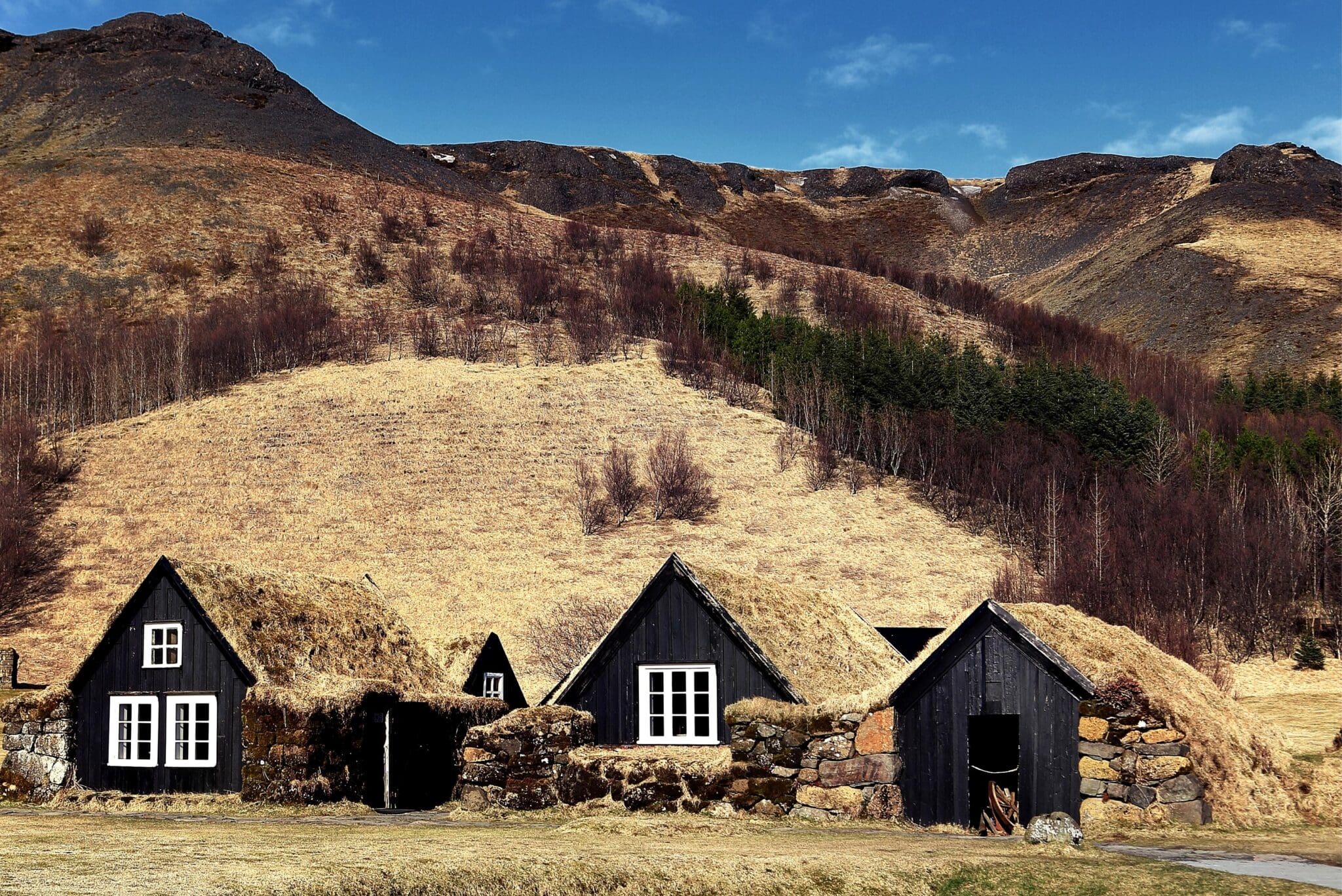
Skógafoss is within the tiny village of Skógar with a population of about 25 people, and the Skógar Regional Museum is close to the waterfall, featuring over 18,000 regional artifacts in six historical buildings. It’s three museums in one which show how Icelanders have lived throughout history; an open-air museum with old wooden houses and turf houses, a folk museum with a cultural heritage collection, and a technical museum showing the evolution of transport, communication, and technology in Iceland. In the folk museum is a noteworthy golden handle that is said to be from a chest filled with gold, owned by the settler Þrasi Þórolfsson who hid the chest behind Skógafoss before his death around AD 900. Attempts were made by many to retrieve it until one day a rope was fixed to the handle to pull the chest out but the handle broke off, leaving the gold-filled chest lost forever. That handle served as a door handle on the Skógakirkja church till 1890.
Resting in the gorge Kvernugil close to Skógafoss is the 30 m (98 ft) high waterfall Kvernufoss which is considered a hidden gem. It is like a counterpart mix of the waterfalls Seljalandsfoss y Gljúfrabúi, being inside a mossy walled canyon with a cave behind it that provides walking behind it.
The beautiful Reynisfjara black sand beach is among the most popular visits in southern Iceland. The unusually black sanded beach with rough ocean waves hitting against the basalt-columned wall makes for a spectacular attraction and in 2021 it was rated by Big 7 Travel as the 6th best beach to visit on their annual list of The 50 Best Beaches In The World, highlighting must-see beaches. Reynisfjara can be very dangerous with its powerful ocean waves and rockfalls from the cliffs due to coastal erosion. Both can often be very unexpected and tragically fatal accidents have happened there throughout the years. It may be tempting to have a picture taken after climbing up onto the basalt columns, but people have been surprised by a sudden “sneaker wave” snatching them and the undertow pulling them out to sea. Nothing can be done if this happens so there’s no turning back after that. The waves can look calm, but close to shore the ocean is extremely deep so the waves are almost unbroken when they reach the beach. The beach itself being steep makes the backwash very strong with a pulling force. Be extremely cautious and please admire these forces of nature at a good distance.
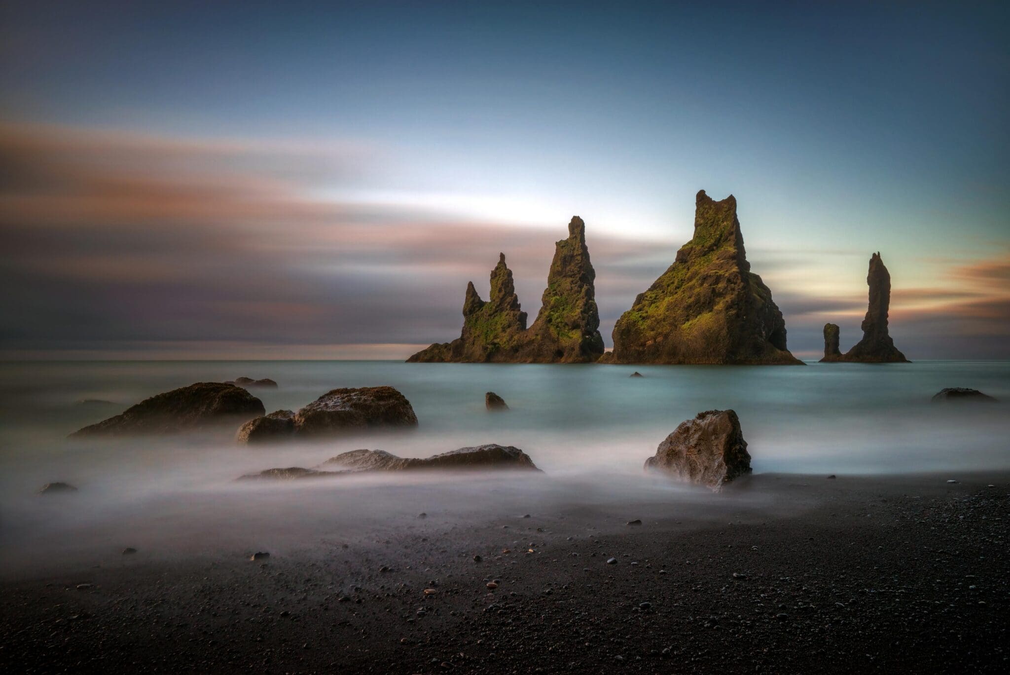
Reynisdrangar is a collection of 66 m (216 ft) high basalt sea pinnacles rising out of the sea by Reynisfjara. An old tale says they originate from when two trolls tried dragging a three-masted ship to land at night, but when daylight broke they along with the ship became these stacks of pinnacles standing out in the sea. Reynisdrangar is the same geological formation as the 340 m (1,115 ft) high mountain Reynisfjall hovering over them. This mountain is made of volcanic tuff from an eruption under a glacier in the penultimate Ice Age, with irregular layers of tuff, pillow lava, and veins and loops of columnar basalt. The mountainsides are steep and by the beach, these beautiful formations of basalt columns can be seen. It is the nesting site of puffins and other sea birds, so please do not try to climb up to them so as not to disturb them. Basalt columns are a great inspiration for Hallgrímskirkja church, Þjóðleikhúsið (e. The National Theatre of Iceland), and Sala de conciertos y centro de conferencias Harpa. In the southern part of Reynisfjara by the beach is Hálsanefshellir, an extremely beautiful basalt cave. Please only try going into it when there’s a low tide so the waves don’t pull you out, and be aware that rocks can suddenly fall.
You may recognize this area from the Icelandic Netflix series Katla, the 7th season of the series Juego de Tronos, the 2013 film Star Trek: Into Darkness, and the 2014 film Noé.
200.195 ISK
193.624 ISK
228.046 ISK
215.138 ISK
200.195 ISK
0 ISK
216.038 ISK
27.999 ISK
165.485 ISK
214.597 ISK
Consejos de viaje, nuevas guías y aviso cuando el pronóstico de auroras se vea bien. Sin spam.